IMAGES TAKEN NEAR TO
Swithun Road, ASHFORD, TN25 7GJ
Introduction
This page details the photographs taken nearby to Swithun Road, TN25 7GJ by members of the Geograph project.
The Geograph project started in 2005 with the aim of publishing, organising and preserving representative images for every square kilometre of Great Britain, Ireland and the Isle of Man.

There are currently over 7.5m images from over14,400 individuals and you can help contribute to the project by visiting https://www.geograph.org.uk
Image Map
Images are licensed for reuse under creativecommons.org/licenses/by-sa/2.0
Notes
- Clicking on the map will re-center to the selected point.
- The higher the marker number, the further away the image location is from the centre of the postcode.
Image Listing (41 Images Found)
Images are licensed for reuse under creativecommons.org/licenses/by-sa/2.0
Image
Details
Distance
1
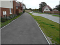
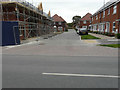
Brambling Avenue
In the distance is Image This is a road on the Finberry housing estate, where houses are still being built.
Image: © John Baker
Taken: 14 Oct 2018
0.05 miles
2
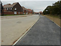
Swift Avenue
At the end of the road, an apartment block which has been named Captains Wood, is under construction. This is a road on the Finberry housing estate, where houses are still being built.
Image: © John Baker
Taken: 14 Oct 2018
0.07 miles
3
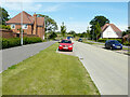
Brambling Avenue
Brambling Avenue is a road on the Finberry housing estate,; a 168 hectare development site which will eventually contain 1180 homes making it the largest single development in Ashford since 2002 https://en.wikipedia.org/wiki/Finberry
A similar view of Image showing that it is still the most westerly end of the road, but for how much longer.
Image: © John Baker
Taken: 11 Jul 2021
0.08 miles
4
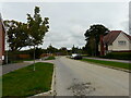
Brambling Avenue
Brambling Avenue is a road on the Finberry housing estate,; a 168 hectare development site which will eventually contain 1180 homes making it the largest single development in Ashford since 2002 https://en.wikipedia.org/wiki/Finberry
A noticeboard, at the far end of the road, points to Sevington Lakes, another housing estate.
This was a similar view of Image, when it was a cul-de-sac.
Image: © John Baker
Taken: 14 Oct 2022
0.09 miles
5
Linnet Drive
A road on the Finberry housing estate, where houses are still being built.
Image: © John Baker
Taken: 14 Oct 2018
0.10 miles
6
The most westerly end of Brambling Avenue
A road on the Finberry housing estate, where houses are still being built.
Image: © John Baker
Taken: 14 Oct 2018
0.12 miles
7
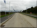
Stonechat Way
The road leads to a housing estate named Sevington Lakes.
Image: © John Baker
Taken: 14 Oct 2022
0.12 miles
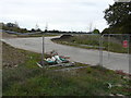
8
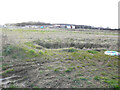
Sevington Lakes from Cheeseman?s Green Lane
The previous view of Image was taken in March 2022.
Image: © John Baker
Taken: 22 May 2022
0.16 miles
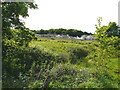
9
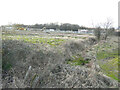
Sevington Lakes from Cheeseman?s Green Lane
Planning permission has been granted by Ashford Borough Council under application number 16/00125/AS for “(land south of Captain’s Wood phase); construction of 326 new dwellings with associated access, parking, landscaped areas including a neighbourhood play area, internal roads for the development, details of distributor roads E and F, Waterbrook link road, a district play area north of Captain's Wood and surface water drainage measures *****amended plans received*****”.
This was the Image in August 2020.
Image: © John Baker
Taken: 6 Mar 2022
0.16 miles
10
Sevington Lakes from Cheeseman?s Green Lane
Planning permission has been granted by Ashford Borough Council under application number 16/00125/AS for “(land south of Captain’s Wood phase); construction of 326 new dwellings with associated access, parking, landscaped areas including a neighbourhood play area, internal roads for the development, details of distributor roads E and F, Waterbrook link road, a district play area north of Captain's Wood and surface water drainage measures *****amended plans received*****”.
Image: © John Baker
Taken: 6 Mar 2022
0.16 miles