IMAGES TAKEN NEAR TO
Cheesemans Green Lane, ASHFORD, TN25 7EX
Introduction
This page details the photographs taken nearby to Cheesemans Green Lane, TN25 7EX by members of the Geograph project.
The Geograph project started in 2005 with the aim of publishing, organising and preserving representative images for every square kilometre of Great Britain, Ireland and the Isle of Man.

There are currently over 7.5m images from over14,400 individuals and you can help contribute to the project by visiting https://www.geograph.org.uk
Image Map (Loading...)


Getting Data...Please wait
Leaflet Map data © OpenStreetMap
Images are licensed for reuse under creativecommons.org/licenses/by-sa/2.0
Notes
- Clicking on the map will re-center to the selected point.
- The higher the marker number, the further away the image location is from the centre of the postcode.
Image Listing (139 Images Found)
Images are licensed for reuse under creativecommons.org/licenses/by-sa/2.0
Image
Details
Distance
1
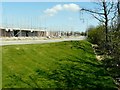
Cheeseman's Green: Bridgefield development
This building work had barely been started during my previous visit on 12 April 2010: for full details of the development see http://www.geograph.org.uk/photo/1802869
Image: © John Baker
Taken: 25 Apr 2010
0.02 miles
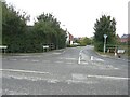
3
Entering Bridgefield from the southeast
Along Cheeseman's Green Lane, which leads into Rutledge Avenue.
Image: © John Baker
Taken: 3 Feb 2013
0.02 miles
4
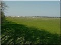
Cheeseman's Green, Bridgefield development
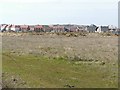
I was standing further down the lane to that of the view I took last year Image and therefore obtained a wider view. The development seems to be heading in a northerly direction rather than advancing any further east, at the moment. There is a fine array of ragwort in the foreground.
Image: © John Baker
Taken: 2 Aug 2011
0.03 miles
5
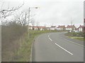
Cheeseman?s Green Lane
The houses, to the right of the road, are part of a developing housing estate, which has been called Bridgefield 2, where 325 homes are to be built http://www.cradick.co.uk/properties/freehold/Bridgefield-Ashford-Ashford/421
Image: © John Baker
Taken: 10 Oct 2021
0.03 miles
6
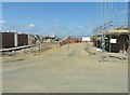
Cheeseman's Green: Bridgefield development
Work had barely begun on this part of the development during my visit of 12 April 2010; for full details see http://www.geograph.org.uk/photo/1802869
Image: © John Baker
Taken: 25 Apr 2010
0.03 miles
7
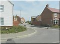
Southdown Close, Bridgefield development
The entrance to the close can be seen opposite the lampposts. The houses at the entrance to the close were being built when I last visited the site http://www.geograph.org.uk/photo/1829416
Image: © John Baker
Taken: 2 Aug 2011
0.04 miles
8
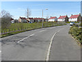
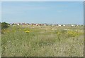
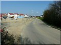
Looking west-northwest along Cheeseman?s Green Lane
Compared with Image, it may be seen how much the hedge has grown beside the road.
Image: © John Baker
Taken: 12 Apr 2015
0.04 miles
9
Cheeseman's Green: Bridgefield development
For full details of the development see http://www.geograph.org.uk/photo/1802869
Image: © John Baker
Taken: 12 Apr 2010
0.04 miles
10
Cheeseman's Green: Bridgefield development
For full details of this development see http://www.geograph.org.uk/photo/1802869
Image: © John Baker
Taken: 12 Apr 2010
0.04 miles