IMAGES TAKEN NEAR TO
Bill Deedes Way, ASHFORD, TN25 7ES
Introduction
This page details the photographs taken nearby to Bill Deedes Way, TN25 7ES by members of the Geograph project.
The Geograph project started in 2005 with the aim of publishing, organising and preserving representative images for every square kilometre of Great Britain, Ireland and the Isle of Man.

There are currently over 7.5m images from over14,400 individuals and you can help contribute to the project by visiting https://www.geograph.org.uk
Image Map (Loading...)


Getting Data...Please wait
Leaflet Map data © OpenStreetMap
Images are licensed for reuse under creativecommons.org/licenses/by-sa/2.0
Notes
- Clicking on the map will re-center to the selected point.
- The higher the marker number, the further away the image location is from the centre of the postcode.
Image Listing (14 Images Found)
Images are licensed for reuse under creativecommons.org/licenses/by-sa/2.0
Image
Details
Distance
1
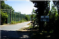
HMP Aldington (disused)
A disused prison in Aldington, near Ashford, abandoned by the HM Prison Service in 1999. Plans have been put forward to turn it into a detention centre for asylum seekers, but these were met with fierce opposition from local residents. Plans have now be revised, and the centre is due to be developed into housing.
Image: © Ben Clifton
Taken: 15 Jul 2006
0.04 miles
2
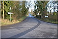
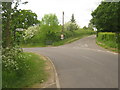
New Road Hill, Aldington
Junction with Boat Lane on right.
Image: © Julian P Guffogg
Taken: 30 Dec 2012
0.07 miles
4
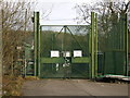
HMP Aldington, Ashford, Kent
Disused prison in one of the outlaying villages around Ashford, Kent.
Not used since 1999. Plans to use it as an Asylum Seeker reception centre have been scrapped.
Image: © C Melia
Taken: 24 Feb 2007
0.09 miles
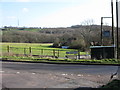
6
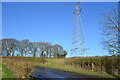
Forge Hill and Mill Lane Junction
Forge Hill leads from Aldington to Bonnington. Mill Lane leads right towards Vale Farm. The Saxon Shore Way (long distance path) heads right along the lane from Blackthorn Wood.
Image: © David Anstiss
Taken: 30 May 2010
0.20 miles
7
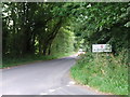
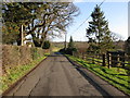
Forge Hill from Mill Lane
New Road Hill and Forge Hill merge at the point where Mill Lane joins.
Image: © Nick Smith
Taken: 17 Jan 2010
0.21 miles
10
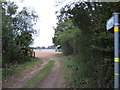
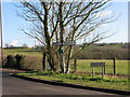
Footpath on Boat Lane
It leads from the lane past South Hurst (part of Stockshill Wood) heading towards Ruffins Hill.
Image: © David Anstiss
Taken: 26 Sep 2010
0.22 miles