IMAGES TAKEN NEAR TO
Main Road, ASHFORD, TN25 6JY
Introduction
This page details the photographs taken nearby to Main Road, TN25 6JY by members of the Geograph project.
The Geograph project started in 2005 with the aim of publishing, organising and preserving representative images for every square kilometre of Great Britain, Ireland and the Isle of Man.

There are currently over 7.5m images from over14,400 individuals and you can help contribute to the project by visiting https://www.geograph.org.uk
Image Map
Images are licensed for reuse under creativecommons.org/licenses/by-sa/2.0
Notes
- Clicking on the map will re-center to the selected point.
- The higher the marker number, the further away the image location is from the centre of the postcode.
Image Listing (50 Images Found)
Images are licensed for reuse under creativecommons.org/licenses/by-sa/2.0
Image
Details
Distance
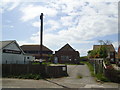
1
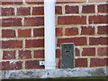
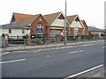
Ordnance Survey Flush Bracket S6388
This can be found on the wall of Sellindge Primary School.
For more detail see : http://www.bench-marks.org.uk/bm19671
Image: © Peter Wood
Taken: 15 Feb 2016
0.00 miles
3
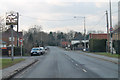
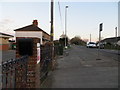
A20 through Sellinge
Towards Ashford.
Image: © J.Hannan-Briggs
Taken: 30 Mar 2013
0.02 miles
4
Road (A20) passing through Sellindge
Looking south-eastward from the Primary School towards the Village Hall.
Image: © Peter Wood
Taken: 15 Feb 2016
0.02 miles
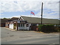
8
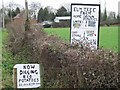
Potatoes for sale
Sign outside Elm Tree Farm
Image: © Nick Smith
Taken: 30 Dec 2007
0.04 miles
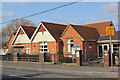
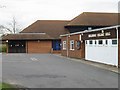
9
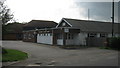
Sellindge Village Hall
On A20 Ashford Road, opposite Sellindge Primary School.
Image: © David Anstiss
Taken: 8 Aug 2009
0.05 miles