IMAGES TAKEN NEAR TO
Brook Lane, ASHFORD, TN25 6HQ
Introduction
This page details the photographs taken nearby to Brook Lane, TN25 6HQ by members of the Geograph project.
The Geograph project started in 2005 with the aim of publishing, organising and preserving representative images for every square kilometre of Great Britain, Ireland and the Isle of Man.

There are currently over 7.5m images from over14,400 individuals and you can help contribute to the project by visiting https://www.geograph.org.uk
Image Map (10 Images)


Leaflet Map data © OpenStreetMap
Images are licensed for reuse under creativecommons.org/licenses/by-sa/2.0
Notes
- Clicking on the map will re-center to the selected point.
- The higher the marker number, the further away the image location is from the centre of the postcode.
Image Listing (10 Images Found)
Images are licensed for reuse under creativecommons.org/licenses/by-sa/2.0
Image
Details
Distance
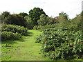
2
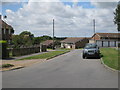
Bungalows on Greenfields, Stanford
Image: © Oast House Archive
Taken: 22 Jul 2010
0.12 miles
3
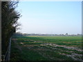
Gibbin's Brook
Looking from Brook Lane over the fields towards the M20 in the distance. The woodland to the left is Gibbin's Brook, an area of CROW land on the outskirts of Sellindge. (See http://www.defra.gov.uk/wildlife-countryside/cl/index.htm for explanation of CROW land)
Image: © Adam Hincks
Taken: 16 Apr 2007
0.12 miles
5
Five Konik ponies graze on land at Gibbin's Brook
A small herd of wild horses are being used to help with the conservation of an east Kent nature reserve. Five Konik ponies will graze on land at Gibbin's Brook, between the villages of Sellindge and Stanford, near Hythe.
It is one of only three surviving pieces of fenland in Kent, and the horses will help prevent it from being invaded by shrubs and trees. (Taken from BBC website see http://news.bbc.co.uk/1/hi/england/kent/7149617.stm ) See also
Image for explanation of area name.
Image: © Nick Smith
Taken: 30 Dec 2007
0.16 miles
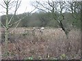
6
Gibbin's Brook
This woodland near Stanford, Ashford is all open access land.
It has Koenig's Ponies wandering around it.
Image: © David Anstiss
Taken: 19 Sep 2010
0.16 miles
7
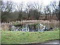
Pond at Gibbin's Brook
The area here is variously known as Gibbin's Brook, Gibbins Brook, Gibbons Brook (in the telephone directory) and Gibbinge Brook by former residents.
Image: © Nick Smith
Taken: 30 Dec 2007
0.17 miles
8
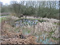
Pond at Gibbin's Brook
The area here is variously known as Gibbin's Brook, Gibbins Brook, Gibbons Brook (in the telephone directory) and Gibbinge Brook by former residence.
Image: © Nick Smith
Taken: 30 Dec 2007
0.18 miles
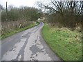
9
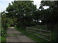
Bridleway and track junction in Gibbin's Brook
A bridleway from Brook Farm leads past and then through the wood (on the right) towards Hope Farm. The track leads left through the wood towards the farm as well.
Image: © David Anstiss
Taken: 19 Sep 2010
0.23 miles
10
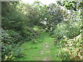
Bridleway in Gibbin's Brook
A bridleway leads from Hayton Lane, past Hope Farm into this wood leading towards Brook Farm.
Image: © David Anstiss
Taken: 19 Sep 2010
0.25 miles