IMAGES TAKEN NEAR TO
Canterbury Road, ASHFORD, TN25 5LQ
Introduction
This page details the photographs taken nearby to Canterbury Road, TN25 5LQ by members of the Geograph project.
The Geograph project started in 2005 with the aim of publishing, organising and preserving representative images for every square kilometre of Great Britain, Ireland and the Isle of Man.

There are currently over 7.5m images from over14,400 individuals and you can help contribute to the project by visiting https://www.geograph.org.uk
Image Map (Loading...)


Getting Data...Please wait
Leaflet Map data © OpenStreetMap
Images are licensed for reuse under creativecommons.org/licenses/by-sa/2.0
Notes
- Clicking on the map will re-center to the selected point.
- The higher the marker number, the further away the image location is from the centre of the postcode.
Image Listing (4 Images Found)
Images are licensed for reuse under creativecommons.org/licenses/by-sa/2.0
Image
Details
Distance
1
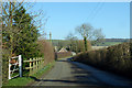
Canterbury Road, Brabourne
Towards Brabourne and Canterbury.
Image: © Robin Webster
Taken: 7 Feb 2020
0.11 miles
2
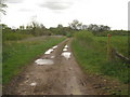
Byway to Canterbury Road
This track leads from the Pilgrim's Way past Coombe farm towards the road near Brabourne School.
Image: © David Anstiss
Taken: 3 May 2010
0.14 miles
3
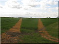
Footpath junction near Coombe farm byway
Both of these paths lead from a byway between Coombe Farm and Canterbury Road, through a large field, towards another footpath (running north-south, between Manor Pound Lane and Bircholt Forstal).
Image: © David Anstiss
Taken: 3 May 2010
0.16 miles
4
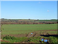
View north from Manor Pound Lane
Looking towards Brabourne Downs.
Image: © Robin Webster
Taken: 8 Dec 2014
0.23 miles