IMAGES TAKEN NEAR TO
Wyndy Lane, ASHFORD, TN25 4PY
Introduction
This page details the photographs taken nearby to Wyndy Lane, TN25 4PY by members of the Geograph project.
The Geograph project started in 2005 with the aim of publishing, organising and preserving representative images for every square kilometre of Great Britain, Ireland and the Isle of Man.

There are currently over 7.5m images from over14,400 individuals and you can help contribute to the project by visiting https://www.geograph.org.uk
Image Map
Images are licensed for reuse under creativecommons.org/licenses/by-sa/2.0
Notes
- Clicking on the map will re-center to the selected point.
- The higher the marker number, the further away the image location is from the centre of the postcode.
Image Listing (24 Images Found)
Images are licensed for reuse under creativecommons.org/licenses/by-sa/2.0
Image
Details
Distance
1
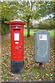
Postbox and Postal Rounds box Orchard Heights
The rather fine Georgian Pillar box was a replacement in 2008 for a smaller box on a post. The grey box alongside is used by delivery postpersons for short-term storage of mail for local delivery, and has been commandeered as an impromptu community notice board.
Image: © Mike Sharpe
Taken: 3 Nov 2009
0.08 miles
2
Forest Avenue
The turning on the right is Sun Rise!
Image: © Robin Webster
Taken: 21 Mar 2010
0.10 miles
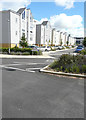
3
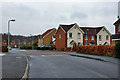
Orchard Heights Estate
Looking north northwest on Orchard Heights Estate
Image: © D-G-Seamon
Taken: 20 Apr 2007
0.11 miles
5
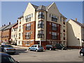
Flats in Repton Park Estate
Flats in St John Fogge Avenue, Repton Park Estate. This estate is on the site of the Templer Barracks
Image: © D-G-Seamon
Taken: 20 Apr 2007
0.17 miles
6
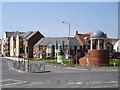
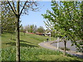
Repton Park Estate entrance
Entrance south west to the new Repton Park Estate from the Maidstone Road
Image: © D-G-Seamon
Taken: 20 Apr 2007
0.19 miles
7
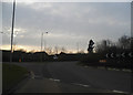
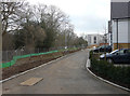
New road on the Bluebells housing estate
If you proceed to the end of this road, turn right and look straight ahead, you will see a view of Image
Image: © John Baker
Taken: 15 Feb 2015
0.19 miles
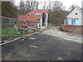
8
Building site beside the A20
The site, known as Bluebells, is to comprise of 61 new homes, which are being built by Pentland Homes http://www.pentlandhomes.co.uk/bluebells.php
Image: © John Baker
Taken: 11 Nov 2013
0.21 miles
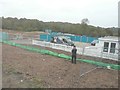
9
New road on the Bluebells housing estate
The wooden railing, on the left, is a safety measure to guard pedestrians from falling into the excavation, which, at the time of my visit, had some water in it. Beyond the excavation is The Warren – a recreational area of woodland.
Image: © John Baker
Taken: 15 Feb 2015
0.22 miles
10
Campion Close
This view of Image shows the road before Pentland Homes had removed their site noticeboard and flags. I assume that Campion Close refers to this and all the other roads in this housing development.
Image: © John Baker
Taken: 24 Jul 2016
0.22 miles