IMAGES TAKEN NEAR TO
Sun Rise, ASHFORD, TN25 4GH
Introduction
This page details the photographs taken nearby to Sun Rise, TN25 4GH by members of the Geograph project.
The Geograph project started in 2005 with the aim of publishing, organising and preserving representative images for every square kilometre of Great Britain, Ireland and the Isle of Man.

There are currently over 7.5m images from over14,400 individuals and you can help contribute to the project by visiting https://www.geograph.org.uk
Image Map
Images are licensed for reuse under creativecommons.org/licenses/by-sa/2.0
Notes
- Clicking on the map will re-center to the selected point.
- The higher the marker number, the further away the image location is from the centre of the postcode.
Image Listing (18 Images Found)
Images are licensed for reuse under creativecommons.org/licenses/by-sa/2.0
Image
Details
Distance
1
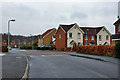
Forest Avenue
The turning on the right is Sun Rise!
Image: © Robin Webster
Taken: 21 Mar 2010
0.03 miles
2
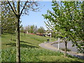
Orchard Heights Estate
Looking north northwest on Orchard Heights Estate
Image: © D-G-Seamon
Taken: 20 Apr 2007
0.08 miles
3
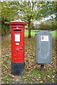
Postbox and Postal Rounds box Orchard Heights
The rather fine Georgian Pillar box was a replacement in 2008 for a smaller box on a post. The grey box alongside is used by delivery postpersons for short-term storage of mail for local delivery, and has been commandeered as an impromptu community notice board.
Image: © Mike Sharpe
Taken: 3 Nov 2009
0.12 miles
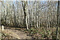
5
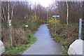
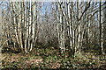
Footpath junction near Lodge Wood
A footpath from Godinton leads over the Channel Tunnel Rail Link footbridge, and then heads straight on to Forest Avenue in the Orchard Heights Estate. Another path heads right to Rose Wood Drive in the estate. Also another path heads left through Lodge Wood to Potters Corner.
Confusingly, the footpath marker on the left shows the Greensand Way heading right. I think this is out-of-date, since the long distance path is shown on the other side of the railway.
Image: © David Anstiss
Taken: 29 Nov 2009
0.20 miles
6
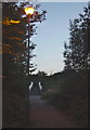
Lamplit Footpath to the Footbridge
A series of streetlamps illuminates a metalled footpath between Orchard Heights Estate and Godinton Park, not shown on the map. As dusk wears on Narnia appears!
Image: © Mike Sharpe
Taken: 23 Aug 2009
0.20 miles
7
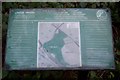
Lodge Wood Information Sign
Seen in Image It shows the paths around the wood beside the Channel Tunnel Rail Link.
Image: © David Anstiss
Taken: 29 Nov 2009
0.21 miles
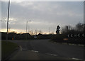
10
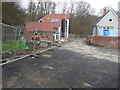
New road on the Bluebells housing estate
If you proceed to the end of this road, turn right and look straight ahead, you will see a view of Image
Image: © John Baker
Taken: 15 Feb 2015
0.23 miles