IMAGES TAKEN NEAR TO
Wellingtonia Close, TN24 0WW
Introduction
This page details the photographs taken nearby to Wellingtonia Close, TN24 0WW by members of the Geograph project.
The Geograph project started in 2005 with the aim of publishing, organising and preserving representative images for every square kilometre of Great Britain, Ireland and the Isle of Man.

There are currently over 7.5m images from over14,400 individuals and you can help contribute to the project by visiting https://www.geograph.org.uk
Image Map
Images are licensed for reuse under creativecommons.org/licenses/by-sa/2.0
Notes
- Clicking on the map will re-center to the selected point.
- The higher the marker number, the further away the image location is from the centre of the postcode.
Image Listing (56 Images Found)
Images are licensed for reuse under creativecommons.org/licenses/by-sa/2.0
Image
Details
Distance
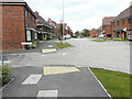
1
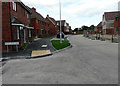
Honeysuckle Avenue, Hinxhill Park
Planning permission has been granted by Ashford Borough Council under application number 16/01722/AS for “full planning application for a new link road to the rear of the William Harvey Hospital from the A20 and 192 dwellings together with associated open space, play equipment, landscaping, drainage, infrastructure and earthworks”.
Image: © John Baker
Taken: 23 Aug 2020
0.04 miles
2
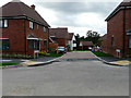
Bellflower Rise, Hinxhill Park
Viewed from its junction with Image Planning permission has been granted by Ashford Borough Council under application number 16/01722/AS for “full planning application for a new link road to the rear of the William Harvey Hospital from the A20 and 192 dwellings together with associated open space, play equipment, landscaping, drainage, infrastructure and earthworks”.
Image: © John Baker
Taken: 23 Aug 2020
0.04 miles
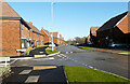
3
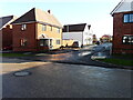
Laburnum Lane, Hinxhill Park
Planning permission has been granted by Ashford Borough Council under application number 16/01722/AS for “full planning application for a new link road to the rear of the William Harvey Hospital from the A20 and 192 dwellings together with associated open space, play equipment, landscaping, drainage, infrastructure and earthworks”.
There was patchy black ice on the road surface and pavements.
Image: © John Baker
Taken: 25 Jan 2021
0.05 miles
4
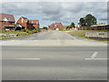
Honeysuckle Avenue, Hinxhill Park
Viewed across Hythe Road (A20), planning permission has been granted by Ashford Borough Council under application number 16/01722/AS for “full planning application for a new link road to the rear of the William Harvey Hospital from the A20 and 192 dwellings together with associated open space, play equipment, landscaping, drainage, infrastructure and earthworks”.
This was Image in October 2019. Work on this housing estate is still ongoing.
Image: © John Baker
Taken: 23 Aug 2020
0.05 miles
5
Honeysuckle Avenue, Hinxhill Park
Planning permission has been granted by Ashford Borough Council under application number 16/01722/AS for “full planning application for a new link road to the rear of the William Harvey Hospital from the A20 and 192 dwellings together with associated open space, play equipment, landscaping, drainage, infrastructure and earthworks”.
This was Image in January 2021.
Image: © John Baker
Taken: 24 Oct 2021
0.06 miles
6
Hinxhill Park, Hythe Road (A20)
Planning permission has been granted by Ashford Borough Council under application number 16/01722/AS for “full planning application for a new link road to the rear of the William Harvey Hospital from the A20 and 192 dwellings together with associated open space, play equipment, landscaping, drainage, infrastructure and earthworks”.
Here the land is being levelled.
This view of Image is slightly to the northwest.
Image: © John Baker
Taken: 21 Feb 2019
0.06 miles
7
Honeysuckle Avenue, Hinxhill Park
Planning permission has been granted by Ashford Borough Council under application number 16/01722/AS for “full planning application for a new link road to the rear of the William Harvey Hospital from the A20 and 192 dwellings together with associated open space, play equipment, landscaping, drainage, infrastructure and earthworks”.
This was Image in August 2020.
Image: © John Baker
Taken: 25 Jan 2021
0.06 miles
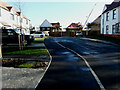
8

Honeysuckle Avenue, Hinxhill Park
It would appear that a realignment of the road’s junction was in progress.
Image: © John Baker
Taken: 24 Oct 2021
0.07 miles
9
Laburnum Lane, Hinxhill Park
Planning permission has been granted by Ashford Borough Council under application number 16/01722/AS for “full planning application for a new link road to the rear of the William Harvey Hospital from the A20 and 192 dwellings together with associated open space, play equipment, landscaping, drainage, infrastructure and earthworks”.
This section of the road lies round the corner, at the far end of Image There was patchy black ice on the road surface and pavements.
Image: © John Baker
Taken: 25 Jan 2021
0.07 miles
10

Honeysuckle Avenue, Hinxhill Park
Viewed across Hythe Road (A20), planning permission has been granted by Ashford Borough Council under application number 16/01722/AS for “full planning application for a new link road to the rear of the William Harvey Hospital from the A20 and 192 dwellings together with associated open space, play equipment, landscaping, drainage, infrastructure and earthworks”.
This was Image in April 2019.
Image: © John Baker
Taken: 20 Oct 2019
0.07 miles