IMAGES TAKEN NEAR TO
Thornton Close, ASHFORD, TN24 0QU
Introduction
This page details the photographs taken nearby to Thornton Close, TN24 0QU by members of the Geograph project.
The Geograph project started in 2005 with the aim of publishing, organising and preserving representative images for every square kilometre of Great Britain, Ireland and the Isle of Man.

There are currently over 7.5m images from over14,400 individuals and you can help contribute to the project by visiting https://www.geograph.org.uk
Image Map
Images are licensed for reuse under creativecommons.org/licenses/by-sa/2.0
Notes
- Clicking on the map will re-center to the selected point.
- The higher the marker number, the further away the image location is from the centre of the postcode.
Image Listing (34 Images Found)
Images are licensed for reuse under creativecommons.org/licenses/by-sa/2.0
Image
Details
Distance
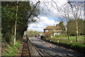
1
M20 Motorway
Heading West between junctions 8 and 9.
Image: © Oast House Archive
Taken: 15 Feb 2010
0.12 miles
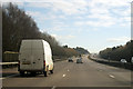
3
Miles of HGV's stacked on the M20 heading to LeShuttle and channel ports
Chaos in Kent due to migrant activity at LeShuttle terminal in France.
Image: © Steve Fareham
Taken: 25 Jul 2015
0.13 miles
5
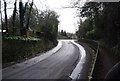
Junction of Blackwall Road North with the A2070
Image: © Nick Smith
Taken: 3 May 2008
0.14 miles
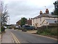
7
Houses on Waltham Close next to the M20
Viewed from the Stour Valley Walk. Willesborough windmill http://www.geograph.org.uk/photo/232011 can just be seen above the houses.
Image: © Nick Smith
Taken: 3 May 2008
0.16 miles
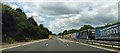
9
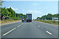
Coast-bound M20
Approaching junction 10.
Image: © Robin Webster
Taken: 8 Jul 2018
0.16 miles