IMAGES TAKEN NEAR TO
Tannery Lane, ASHFORD, TN23 9SL
Introduction
This page details the photographs taken nearby to Tannery Lane, TN23 9SL by members of the Geograph project.
The Geograph project started in 2005 with the aim of publishing, organising and preserving representative images for every square kilometre of Great Britain, Ireland and the Isle of Man.

There are currently over 7.5m images from over14,400 individuals and you can help contribute to the project by visiting https://www.geograph.org.uk
Image Map
Images are licensed for reuse under creativecommons.org/licenses/by-sa/2.0
Notes
- Clicking on the map will re-center to the selected point.
- The higher the marker number, the further away the image location is from the centre of the postcode.
Image Listing (239 Images Found)
Images are licensed for reuse under creativecommons.org/licenses/by-sa/2.0
Image
Details
Distance

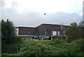
4

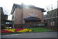
The Stour Centre, Ashford
Ashford's leisure centre http://www.thestourcentre.co.uk/
Image: © Nick Smith
Taken: 23 Apr 2009
0.05 miles
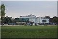
5
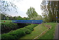
The Stour Centre, Ashford
Seen across the East Stour from the footpath/cycleway beside it. The tower of St Mary's church is to the left of the centre.
Image: © John Baker
Taken: 22 Apr 2012
0.05 miles
6
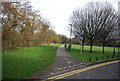
Stour Centre
http://www.ashfordleisuretrust.co.uk/the-stour-centre.html
Image: © N Chadwick
Taken: 15 Apr 2011
0.06 miles

8
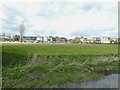
The Stour Centre
A large leisure centre. http://www.ashfordleisuretrust.co.uk/the-stour-centre.html
Image: © N Chadwick
Taken: 15 Apr 2011
0.06 miles