IMAGES TAKEN NEAR TO
Victoria Road, ASHFORD, TN23 7AJ
Introduction
This page details the photographs taken nearby to Victoria Road, TN23 7AJ by members of the Geograph project.
The Geograph project started in 2005 with the aim of publishing, organising and preserving representative images for every square kilometre of Great Britain, Ireland and the Isle of Man.

There are currently over 7.5m images from over14,400 individuals and you can help contribute to the project by visiting https://www.geograph.org.uk
Image Map
Images are licensed for reuse under creativecommons.org/licenses/by-sa/2.0
Notes
- Clicking on the map will re-center to the selected point.
- The higher the marker number, the further away the image location is from the centre of the postcode.
Image Listing (334 Images Found)
Images are licensed for reuse under creativecommons.org/licenses/by-sa/2.0
Image
Details
Distance
1
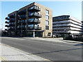
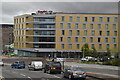
Victoria Point, Victoria Road
The development is described by the estate agent Savills as being an exemplary scheme of 216 apartments, meticulously designed and luxuriously appointed.
Victoria Point benefits from a secure gated underground car park and dedicated secure bicycle storage. Additional parking is provided in the form of a riverside car park, closely linked to the landscaped gardens and river walk which become a focal point for leisure and relaxation within the development.
All apartments benefit from private amenity space in the form of either balconies or terraces, which have views over the landscaped courtyard or the River Great Stour. Penthouse suites also benefit from roof gardens with large sliding doors to maximise the feeling of space and freedom of the private outside environment https://search.savills.com/property-detail/gbsvrdsed180076?gclid=EAIaIQobChMIzMyAuqSO6QIVikPTCh22XQ7qEAAYASAAEgLS7_D_BwE
Image: © John Baker
Taken: 23 Mar 2020
0.01 miles
2
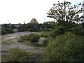
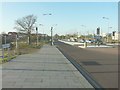
Development Opportunity?
Vacant plot opposite Ashford International Railway Station.
Image: © Ian Paterson
Taken: 10 Sep 2008
0.02 miles
3
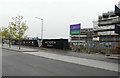
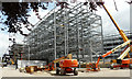
Victoria Point, Victoria Road
It was reported in the Kent Messenger newspaper on 8 August 2018 that “a new luxury hotel and residential development being built near Ashford town centre is scheduled to open in spring 2020.
The Victoria Point scheme is transforming an empty site in Victoria Road opposite the new Aldi supermarket and next to the train station.
Development company Elevate Property Group is building 216 apartments including one, two and three-bedroom flats, costing between £142,500 to £340,000” https://www.kentonline.co.uk/ashford/news/hotel-and-flats-to-open-in-under-two-years-188150/
Victoria Point includes the Image
Image: © John Baker
Taken: 14 Oct 2019
0.02 miles
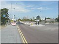
6
Victoria Road, Ashford
The construction of the new link between this road and Leacon Road has been completed Image although the Ashford Borough Council link is somewhat misleading to suggest that it will be renamed Victoria Way. I feel only this section Image bears the new name, as the nameplate in this view still shows Victoria Road.
Image: © John Baker
Taken: 15 Jan 2012
0.03 miles
7
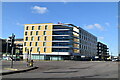
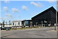
Victoria Road/George Street redevelopment site
Planning permission has been granted by Ashford Borough Council under application number 16/00002/EIA/AS for “a food store (Use Class A1) – up to 1,750sq.m. A brewery (Use Class B2) with ancillary shop, bar and restaurant – up to 2,200sq.m. A[n] hotel (Use Class C1) - up to 120 bedrooms. Small scale commercial units (Use Classes B1a/A1/A2) – up to 350sq.m total. Up to 225 residential units comprising flats of mixed sizes (majority 1-2 beds with some 3 bed units). Dwellings to comprise a mix of Private Rented Sector (PRS), and market housing. Two electrical sub-stations. Associated parking, landscaping and access works”.
Image: © John Baker
Taken: 3 Jun 2019
0.04 miles
9
Victoria Road, Ashford
Victoria Road is to become Victoria Way - a new route to link the International station at Beaver Road and the A28 Chart Road. It will follow the existing Victoria Road to Cherry Court where a new road will be built to join the end of Leacon Road by Matalan at the Fairwood Industrial Park http://www.ashford.gov.uk/transport_and_streets/road_improvements.aspx
Image: © John Baker
Taken: 2 Aug 2011
0.05 miles
10
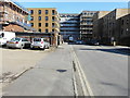
Victoria Crescent
On the left, with its frontage covered with scaffolding, is Image; on the right, mostly in shadow, are residential apartments and at the end of the road is the Victoria Road/George Street development.
These were the Image and this was the Image; both photographed in June 2019.
Image: © John Baker
Taken: 23 Mar 2020
0.05 miles