IMAGES TAKEN NEAR TO
Russett Close, ASHFORD, TN23 5JH
Introduction
This page details the photographs taken nearby to Russett Close, TN23 5JH by members of the Geograph project.
The Geograph project started in 2005 with the aim of publishing, organising and preserving representative images for every square kilometre of Great Britain, Ireland and the Isle of Man.

There are currently over 7.5m images from over14,400 individuals and you can help contribute to the project by visiting https://www.geograph.org.uk
Image Map
Images are licensed for reuse under creativecommons.org/licenses/by-sa/2.0
Notes
- Clicking on the map will re-center to the selected point.
- The higher the marker number, the further away the image location is from the centre of the postcode.
Image Listing (22 Images Found)
Images are licensed for reuse under creativecommons.org/licenses/by-sa/2.0
Image
Details
Distance
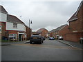
1
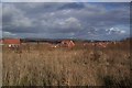
The Greensand Way heads towards Great Chart
The long distance path on a bridleway heads past a new housing estate (the De Montfort Park Development), towards a bridleway bridge over the A28 Ashford Road, from Mock Lane.
Image: © David Anstiss
Taken: 29 Nov 2009
0.03 miles
2
Footpath junction on Greensand Way near Singleton
The long distance path heads straight on to Bucksford Lane. Another footpath should head left (at 90 degrees, towards Swaffer Way), but a more popular route is to angle towards Great Fishers leading to Swaffer Way. The stile on the right is not used and the sign on it shows the adaptations to the footpath due to the new housing estate of De Montfort Park near Singleton.
Image: © David Anstiss
Taken: 29 Nov 2009
0.05 miles
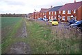
3
Redrow Houses near Singleton
Redrow is building more houses on the west of Singleton. The Paddocks is the sixth phase of a De Montfort Park development on Tithe Barn Lane.
See http://www.redrow.co.uk/assets/uploaded/documents/100_The%20Paddocks%20brochure.pdf for more details.
Image: © David Anstiss
Taken: 29 Nov 2009
0.08 miles
4
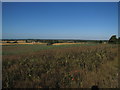
View over Singleton and Ashford
Seen from the Greensand Way (long distance path) near Bucksford Lane.
View looks North-eastwards to the North Downs near Ashford. It looks over the new De Montford Park housing Estate.
Image: © David Anstiss
Taken: 29 Nov 2009
0.13 miles
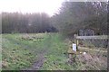
6
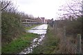
Bridge over the A28 Ashford Road
This bridge is used by a bridleway heading from Great Chart to Mock Lane. It is also used by the Greensand Way (long distance path).
Image: © David Anstiss
Taken: 29 Nov 2009
0.15 miles
7
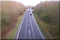
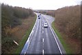
A28 Ashford Road towards Ashford
Seen from the bridleway bridge near Great Chart. The A28 leads from Tenterden and Bethersden to Ashford.
Image: © David Anstiss
Taken: 29 Nov 2009
0.15 miles
8
A28 Ashford Road towards Bethersden
Seen from the bridleway bridge near Great Chart. The A28 leads from Ashford to Bethersden and Tenterden.
Image: © David Anstiss
Taken: 29 Nov 2009
0.16 miles
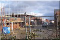
9
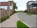
Woodland Rise
Planning permission has been granted by Ashford Borough Council under application number 12/00400/AS, for an “outline application for a Comprehensive Mixed Use Development comprising: up to 5,750 residential units, in a mix of sizes, types and tenures; up to 10,000 m² (gross external floor space) of Class Bl use; up to 9,000 m² (gross external floor space) of Class Al to A5 uses; Education (including a secondary school of up to 8 ha and up to four primary schools of up to 2.1 ha each); Community Uses (class Dl) up to 7,000 m² (gross external floor space); Leisure Uses (class D2) up to 6,000 m² (gross external floor space); Provision of local recycling facilities; Provision of areas of formal and informal open space; Installation of appropriate utilities infrastructure as required to serve the development, including flood attenuation works, SUDS, water supply and wastewater infrastructure, gas supply, electricity supply (including substations), telecommunications infrastructure and renewable energy infrastructure (including CHP in the District Centre); Transport infrastructure, including provision of three accesses on to the A28, an access on to Coulter Road/Cuckoo Lane, other connections on to the local road network, and a network of internal roads, footpaths and cycle routes; New planting and landscaping, both within the Proposed Development and on its boundaries, and ecological enhancement works; and associated ground works where appearance, landscaping, layout and scale are reserved for future approval and where access is reserved for future approval with the exception of the three accesses on to the A28 and the access on to Coulter Road/Cuckoo Lane”.
The road is part of the Chilmington Green development and this part is at the far end of the view of Image
Image: © John Baker
Taken: 6 Jun 2021
0.17 miles