IMAGES TAKEN NEAR TO
Bryony Drive, ASHFORD, TN23 3RF
Introduction
This page details the photographs taken nearby to Bryony Drive, TN23 3RF by members of the Geograph project.
The Geograph project started in 2005 with the aim of publishing, organising and preserving representative images for every square kilometre of Great Britain, Ireland and the Isle of Man.

There are currently over 7.5m images from over14,400 individuals and you can help contribute to the project by visiting https://www.geograph.org.uk
Image Map
Images are licensed for reuse under creativecommons.org/licenses/by-sa/2.0
Notes
- Clicking on the map will re-center to the selected point.
- The higher the marker number, the further away the image location is from the centre of the postcode.
Image Listing (14 Images Found)
Images are licensed for reuse under creativecommons.org/licenses/by-sa/2.0
Image
Details
Distance
1
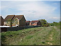
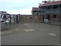
Footpath alongside A2070
A2070 to left. Modern housing on Lapwing Drive to left.
Image: © Oast House Archive
Taken: 14 May 2010
0.17 miles
2
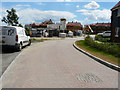
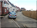
Wiltshire Gardens
On the Bridgefield housing estate.
Image: © John Baker
Taken: 31 Jul 2016
0.21 miles
3
Wiltshire Gardens
A lot has changed since I last photographed Image, on the Bridgefield housing estate.
Image: © John Baker
Taken: 9 Jul 2017
0.21 miles
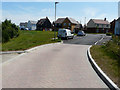
4
Wiltshire Gardens
This image of Image shows the road before two road signs were installed to indicate where Wiltshire Gardens become Ryeland Way. Their location is in front of the house with red brickwork and black weatherboarding above. The road is part of the Bridgefield housing estate.
Image: © John Baker
Taken: 14 Oct 2018
0.22 miles
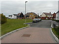
5
Houses under construction, Wiltshire Gardens
On the Bridgefield housing estate.
Image: © John Baker
Taken: 31 Jul 2016
0.22 miles
6
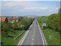
A2070 Road
Looking toward Ashford from footbridge.
Image: © Oast House Archive
Taken: 14 May 2010
0.22 miles
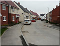
7

Looking north-northwest along Ryeland Way
On the Bridgefield housing estate.
Image: © John Baker
Taken: 17 Jan 2016
0.23 miles
8
Looking north-northwest along Ryland Way
Compared with Image little has changed. The houses are on the Bridgefield housing estate.
Image: © John Baker
Taken: 7 Feb 2016
0.23 miles
9
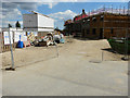
Houses under construction, Ryeland Way
On the Bridgefield housing estate.
Image: © John Baker
Taken: 17 Jan 2016
0.23 miles
10
Looking north along Ryland Way
Compared with Image, the construction of houses, on the right side of the road, has been completed but more tarmac has yet to be added to the pavements to raise the level to the tops of the kerbstones. This is part of the Bridgefield housing estate.
Image: © John Baker
Taken: 12 Mar 2017
0.23 miles