IMAGES TAKEN NEAR TO
Field View, ASHFORD, TN23 3NZ
Introduction
This page details the photographs taken nearby to Field View, TN23 3NZ by members of the Geograph project.
The Geograph project started in 2005 with the aim of publishing, organising and preserving representative images for every square kilometre of Great Britain, Ireland and the Isle of Man.

There are currently over 7.5m images from over14,400 individuals and you can help contribute to the project by visiting https://www.geograph.org.uk
Image Map
Images are licensed for reuse under creativecommons.org/licenses/by-sa/2.0
Notes
- Clicking on the map will re-center to the selected point.
- The higher the marker number, the further away the image location is from the centre of the postcode.
Image Listing (22 Images Found)
Images are licensed for reuse under creativecommons.org/licenses/by-sa/2.0
Image
Details
Distance
1
From the top of the tower of St Michael and All Angels, Kingsnorth in 1977
There were celebrations to mark the Queen’s Silver Jubilee entitled ‘Bygone Kingsnorth’ and members of the public were permitted to ascend the tower for views from the top. This view was taken during the evening before the Park Farm development was even considered. In the far distance the tower of St Mary's parish church, Ashford can just be made out to the left of the tall building that is Charter House, while to its right is the office block in Station Road opposite the railway station.
Image: © John Baker
Taken: 10 Jun 1977
0.08 miles
5
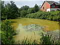
Pond at Park Farm
This pond in the new development of Park Farm at Kingsnorth no doubt predates the new houses.
Image: © Marathon
Taken: 3 Aug 2021
0.13 miles
7
Tudor Farm Close, Kingsnorth
This small development lies on the north side of Church Hill and was built on the land of Tudor Farm. The house at the entrance to the close on the left is Tudor House.
Image: © John Baker
Taken: 31 Jan 2010
0.15 miles
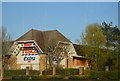
8
5, Church Hill
Planning permission was granted by Ashford Borough Council under application number 15/00690/AS for the “demolition of existing single storey side extension and erection of two storey side extension including integral garage”.
Image: © John Baker
Taken: 9 Jul 2017
0.17 miles
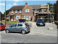
9
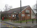
Kingsnorth Village Hall
On Church Hill.
Image: © David Anstiss
Taken: 21 Feb 2010
0.18 miles
10
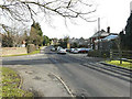
Church Hill, Kingsnorth
The side road is South Lea while almost opposite is Forge Garage - a car servicing/repair business.
Image: © John Baker
Taken: 31 Jan 2010
0.18 miles