IMAGES TAKEN NEAR TO
Romney Point, ASHFORD, TN23 3GD
Introduction
This page details the photographs taken nearby to Romney Point, TN23 3GD by members of the Geograph project.
The Geograph project started in 2005 with the aim of publishing, organising and preserving representative images for every square kilometre of Great Britain, Ireland and the Isle of Man.

There are currently over 7.5m images from over14,400 individuals and you can help contribute to the project by visiting https://www.geograph.org.uk
Image Map
Images are licensed for reuse under creativecommons.org/licenses/by-sa/2.0
Notes
- Clicking on the map will re-center to the selected point.
- The higher the marker number, the further away the image location is from the centre of the postcode.
Image Listing (43 Images Found)
Images are licensed for reuse under creativecommons.org/licenses/by-sa/2.0
Image
Details
Distance
1
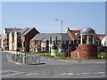
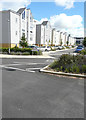
Repton Park Estate entrance
Entrance south west to the new Repton Park Estate from the Maidstone Road
Image: © D-G-Seamon
Taken: 20 Apr 2007
0.05 miles
2
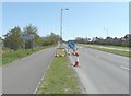
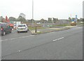
Lane closure on Maidstone Road (A20)
The notice to the left of the blue arrow states "work starts here Mon 22 April for 6 weeks". This is probably connected with the entrance to Image
Image: © John Baker
Taken: 28 Apr 2013
0.07 miles
3
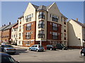
Flats in Repton Park Estate
Flats in St John Fogge Avenue, Repton Park Estate. This estate is on the site of the Templer Barracks
Image: © D-G-Seamon
Taken: 20 Apr 2007
0.07 miles
4
Derelict Buildings beside Maidstone Road (A20)
Image: © John Baker
Taken: 28 Apr 2013
0.08 miles
5
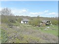
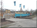
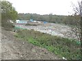
Development land beside Maidstone Road (A20)
The site, to be known as Bluebells, is to comprise of 61 new homes, which are being built by Pentland Homes https://www.pentlandhomes.co.uk/ There used to be Image here.
Image: © John Baker
Taken: 11 Nov 2013
0.09 miles
6
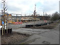
The part of the Bluebells building site still under construction
Almost two years ago one would have seen these Image, as they used to occupy this location.
Image: © John Baker
Taken: 25 Jan 2015
0.09 miles
7
Erection of houses on the Bluebells housing estate
Compared with Image, the construction of the houses has progressed rapidly.
Image: © John Baker
Taken: 15 Feb 2015
0.09 miles
8
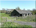
Derelict buildings beside Maidstone Road (A20)
Image: © John Baker
Taken: 28 Apr 2013
0.09 miles
9
Campion Close
This view of Image shows the road before Pentland Homes had removed their site noticeboard and flags. I assume that Campion Close refers to this and all the other roads in this housing development.
Image: © John Baker
Taken: 24 Jul 2016
0.11 miles
10
Site of Bluebells housing estate, Maidstone Road (A20)
The site is to comprise of 61 new homes, which are being built by Pentland Homes https://www.pentlandhomes.co.uk/ There used to be Image here.
Image: © John Baker
Taken: 11 Nov 2013
0.11 miles