IMAGES TAKEN NEAR TO
Caravan Site, Chilmington Green, ASHFORD, TN23 3DT
Introduction
This page details the photographs taken nearby to Caravan Site, Chilmington Green, TN23 3DT by members of the Geograph project.
The Geograph project started in 2005 with the aim of publishing, organising and preserving representative images for every square kilometre of Great Britain, Ireland and the Isle of Man.

There are currently over 7.5m images from over14,400 individuals and you can help contribute to the project by visiting https://www.geograph.org.uk
Image Map
Images are licensed for reuse under creativecommons.org/licenses/by-sa/2.0
Notes
- Clicking on the map will re-center to the selected point.
- The higher the marker number, the further away the image location is from the centre of the postcode.
Image Listing (21 Images Found)
Images are licensed for reuse under creativecommons.org/licenses/by-sa/2.0
Image
Details
Distance
2
Bucksford Lane becomes Mock Lane
Bucksford Lane is from Singleton, Mock Lane leads to Magpie Hall Lane. Seen from opposite Chart Road. The bridleway on the right is part of the Greensand Way leading right to Great Chart, it also leads down Mock Lane towards Chilmington Green.
Image: © David Anstiss
Taken: 29 Nov 2009
0.07 miles
4

Mock Lane
Lane from Singleton, Ashford to Magpie Hall Lane. Also used by the Greensand Way heading to Chilmington Green Farm, from Great Chart.
Image: © David Anstiss
Taken: 29 Nov 2009
0.09 miles
5

Communications Mast on Mock Lane
At the entrance to Cemex ReadyMix Concrete Works (Ashford Plant).
Image: © David Anstiss
Taken: 29 Nov 2009
0.11 miles
6
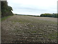
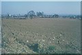
Farmland, Bartlets Lane
The farmland will eventually become part of a vast development, to be known as Chilmington Green.
Planning permission has been granted by Ashford Borough Council under application number 12/00400/AS. This is an “outline application for a Comprehensive Mixed Use Development comprising: up to 5,750 residential units, in a mix of sizes, types and tenures; up to 10,000 m² (gross external floor space) of Class Bl use; up to 9,000 m² (gross external floor space) of Class Al to A5 uses; Education (including a secondary school of up to 8 ha and up to four primary schools of up to 2.1 ha each); Community Uses (class Dl) up to 7,000 m² (gross external floor space); Leisure Uses (class D2) up to 6,000 m² (gross external floor space); Provision of local recycling facilities; Provision of areas of formal and informal open space; Installation of appropriate utilities infrastructure as required to serve the development, including flood attenuation works, SUDS, water supply and wastewater infrastructure, gas supply, electricity supply (including substations), telecommunications infrastructure and renewable energy infrastructure (including CHP in the District Centre); Transport infrastructure, including provision of three accesses on to the A28, an access on to Coulter Road/Cuckoo Lane, other connections on to the local road network, and a network of internal roads, footpaths and cycle routes; New planting and landscaping, both within the Proposed Development and on its boundaries, and ecological enhancement works; and associated ground works where appearance, landscaping, layout and scale are reserved for future approval and where access is reserved for future approval with the exception of the three accesses on to the A28 and the access on to Coulter Road/Cuckoo Lane”.
The trees, on the right, are part of Colemans Kitchen Wood.
Image: © John Baker
Taken: 10 Oct 2017
0.13 miles
7
View towards Ashford from Bucksford Lane in 1975
The ploughed fields are now a public open space. In this view, the gas holder (now demolished) was situated near to Gasworks Lane, to its right is Chart House and (the tower) of St Mary's church, while in the far distance are the North Downs.
Image: © John Baker
Taken: Unknown
0.14 miles
8

View over Singleton and Ashford
Seen from the Greensand Way (long distance path) near Bucksford Lane.
View looks North-eastwards to the North Downs near Ashford. It looks over the new De Montford Park housing Estate.
Image: © David Anstiss
Taken: 29 Nov 2009
0.15 miles
9
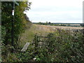
Footpath signpost, Mock Lane
Footpath AW226, also known as the Greensand Way, crosses farmland, which will eventually become part of a vast development, to be known as Chilmington Green.
Planning permission has been granted by Ashford Borough Council under application number 12/00400/AS. This is an “outline application for a Comprehensive Mixed Use Development comprising: up to 5,750 residential units, in a mix of sizes, types and tenures; up to 10,000 m² (gross external floor space) of Class Bl use; up to 9,000 m² (gross external floor space) of Class Al to A5 uses; Education (including a secondary school of up to 8 ha and up to four primary schools of up to 2.1 ha each); Community Uses (class Dl) up to 7,000 m² (gross external floor space); Leisure Uses (class D2) up to 6,000 m² (gross external floor space); Provision of local recycling facilities; Provision of areas of formal and informal open space; Installation of appropriate utilities infrastructure as required to serve the development, including flood attenuation works, SUDS, water supply and wastewater infrastructure, gas supply, electricity supply (including substations), telecommunications infrastructure and renewable energy infrastructure (including CHP in the District Centre); Transport infrastructure, including provision of three accesses on to the A28, an access on to Coulter Road/Cuckoo Lane, other connections on to the local road network, and a network of internal roads, footpaths and cycle routes; New planting and landscaping, both within the Proposed Development and on its boundaries, and ecological enhancement works; and associated ground works where appearance, landscaping, layout and scale are reserved for future approval and where access is reserved for future approval with the exception of the three accesses on to the A28 and the access on to Coulter Road/Cuckoo Lane”.
Image: © John Baker
Taken: 10 Oct 2017
0.17 miles
10
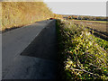
Chart Road
The field, to the right of the road, will eventually form part of a vast development, to be known as Chilmington Green, for which planning permission has been granted by Ashford Borough Council under application number 12/00400/AS. This is an “outline application for a Comprehensive Mixed Use Development comprising: up to 5,750 residential units, in a mix of sizes, types and tenures; up to 10,000 m² (gross external floor space) of Class Bl use; up to 9,000 m² (gross external floor space) of Class Al to A5 uses; Education (including a secondary school of up to 8 ha and up to four primary schools of up to 2.1 ha each); Community Uses (class Dl) up to 7,000 m² (gross external floor space); Leisure Uses (class D2) up to 6,000 m² (gross external floor space); Provision of local recycling facilities; Provision of areas of formal and informal open space; Installation of appropriate utilities infrastructure as required to serve the development, including flood attenuation works, SUDS, water supply and wastewater infrastructure, gas supply, electricity supply (including substations), telecommunications infrastructure and renewable energy infrastructure (including CHP in the District Centre); Transport infrastructure, including provision of three accesses on to the A28, an access on to Coulter Road/Cuckoo Lane, other connections on to the local road network, and a network of internal roads, footpaths and cycle routes; New planting and landscaping, both within the Proposed Development and on its boundaries, and ecological enhancement works; and associated ground works where appearance, landscaping, layout and scale are reserved for future approval and where access is reserved for future approval with the exception of the three accesses on to the A28 and the access on to Coulter Road/Cuckoo Lane”.
Image: © John Baker
Taken: 19 Nov 2017
0.19 miles