IMAGES TAKEN NEAR TO
Chilmington Green Road, ASHFORD, TN23 3DL
Introduction
This page details the photographs taken nearby to Chilmington Green Road, TN23 3DL by members of the Geograph project.
The Geograph project started in 2005 with the aim of publishing, organising and preserving representative images for every square kilometre of Great Britain, Ireland and the Isle of Man.

There are currently over 7.5m images from over14,400 individuals and you can help contribute to the project by visiting https://www.geograph.org.uk
Image Map
Images are licensed for reuse under creativecommons.org/licenses/by-sa/2.0
Notes
- Clicking on the map will re-center to the selected point.
- The higher the marker number, the further away the image location is from the centre of the postcode.
Image Listing (46 Images Found)
Images are licensed for reuse under creativecommons.org/licenses/by-sa/2.0
Image
Details
Distance
1
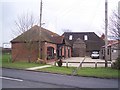
New Street Farm
On Bethersden Road. The brick building is an office for Judges Farm (on the opposite side of the road)
Image: © David Anstiss
Taken: 24 Jan 2010
0.04 miles
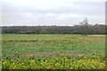
3
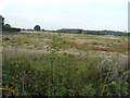
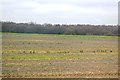
Farmland, Chilmington Green Road
This will form part of a vast development, to be known as Chilmington Green, for which planning permission has been granted by Ashford Borough Council under application number 12/00400/AS. This is an “outline application for a Comprehensive Mixed Use Development comprising: up to 5,750 residential units, in a mix of sizes, types and tenures; up to 10,000 m² (gross external floor space) of Class Bl use; up to 9,000 m² (gross external floor space) of Class Al to A5 uses; Education (including a secondary school of up to 8 ha and up to four primary schools of up to 2.1 ha each); Community Uses (class Dl) up to 7,000 m² (gross external floor space); Leisure Uses (class D2) up to 6,000 m² (gross external floor space); Provision of local recycling facilities; Provision of areas of formal and informal open space; Installation of appropriate utilities infrastructure as required to serve the development, including flood attenuation works, SUDS, water supply and wastewater infrastructure, gas supply, electricity supply (including substations), telecommunications infrastructure and renewable energy infrastructure (including CHP in the District Centre); Transport infrastructure, including provision of three accesses on to the A28, an access on to Coulter Road/Cuckoo Lane, other connections on to the local road network, and a network of internal roads, footpaths and cycle routes; New planting and landscaping, both within the Proposed Development and on its boundaries, and ecological enhancement works; and associated ground works where appearance, landscaping, layout and scale are reserved for future approval and where access is reserved for future approval with the exception of the three accesses on to the A28 and the access on to Coulter Road/Cuckoo Lane”.
Here, there has already been some development, as a layer of grass has been stripped off and a consignment of drainage pipes has been placed in one corner of the meadow.
Image: © John Baker
Taken: 28 Aug 2017
0.06 miles
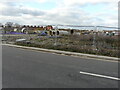
4
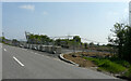
Expansion of the Chilmington Green development
Image: © John Baker
Taken: 14 May 2023
0.11 miles
6
Mock Lane
The view, from the lane, shows the ever increasing number of houses, which have been constructed.
The lane is part of the Chilmington Green development for which planning permission has been granted by Ashford Borough Council under application number 12/00400/AS, for an “outline application for a comprehensive mixed use development comprising: up to 5,750 residential units”.
Image: © John Baker
Taken: 6 Mar 2022
0.14 miles
7
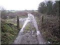
Start of the byway to Bethersden Road
This long byway leads from Magpie Hall Lane towards Bethersden Road, past Possingham Farm House and Calais Wood.
Image: © David Anstiss
Taken: 24 Jan 2010
0.15 miles
8
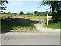
Rerouted footpath, Mock Lane
Because of the development associated with the Chilmington Green housing scheme, this footpath has been rerouted and a map, attached to the signpost, shows the new route.
This image of Image shows the location of the footpath signpost.
Image: © John Baker
Taken: 27 May 2018
0.15 miles
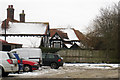
10
Construction site, Mock Lane
This will eventually form part of a vast development, to be known as Chilmington Green, for which planning permission has been granted by Ashford Borough Council under application number 12/00400/AS. This is an “outline application for a Comprehensive Mixed Use Development comprising: up to 5,750 residential units, in a mix of sizes, types and tenures; up to 10,000 m² (gross external floor space) of Class Bl use; up to 9,000 m² (gross external floor space) of Class Al to A5 uses; Education (including a secondary school of up to 8 ha and up to four primary schools of up to 2.1 ha each); Community Uses (class Dl) up to 7,000 m² (gross external floor space); Leisure Uses (class D2) up to 6,000 m² (gross external floor space); Provision of local recycling facilities; Provision of areas of formal and informal open space; Installation of appropriate utilities infrastructure as required to serve the development, including flood attenuation works, SUDS, water supply and wastewater infrastructure, gas supply, electricity supply (including substations), telecommunications infrastructure and renewable energy infrastructure (including CHP in the District Centre); Transport infrastructure, including provision of three accesses on to the A28, an access on to Coulter Road/Cuckoo Lane, other connections on to the local road network, and a network of internal roads, footpaths and cycle routes; New planting and landscaping, both within the Proposed Development and on its boundaries, and ecological enhancement works; and associated ground works where appearance, landscaping, layout and scale are reserved for future approval and where access is reserved for future approval with the exception of the three accesses on to the A28 and the access on to Coulter Road/Cuckoo Lane”.
Image: © John Baker
Taken: 19 Nov 2017
0.16 miles