IMAGES TAKEN NEAR TO
Ninn Lane, ASHFORD, TN23 3DB
Introduction
This page details the photographs taken nearby to Ninn Lane, TN23 3DB by members of the Geograph project.
The Geograph project started in 2005 with the aim of publishing, organising and preserving representative images for every square kilometre of Great Britain, Ireland and the Isle of Man.

There are currently over 7.5m images from over14,400 individuals and you can help contribute to the project by visiting https://www.geograph.org.uk
Image Map
Images are licensed for reuse under creativecommons.org/licenses/by-sa/2.0
Notes
- Clicking on the map will re-center to the selected point.
- The higher the marker number, the further away the image location is from the centre of the postcode.
Image Listing (71 Images Found)
Images are licensed for reuse under creativecommons.org/licenses/by-sa/2.0
Image
Details
Distance
3
Forge Stores, Great Chart
Grade II listed. http://www.britishlistedbuildings.co.uk/en-180951-forge-stores-great-chart-with-singleton
Image: © N Chadwick
Taken: 15 Apr 2011
0.04 miles
4
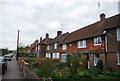
Houses on The Street, Great Chart
All are grade II listed buildings.
Image: © Robin Webster
Taken: 17 Jan 2019
0.04 miles
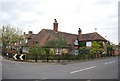
5
Row of Cottages, The Street
All are Grade II listed. eg http://www.britishlistedbuildings.co.uk/en-180954-14-great-chart-with-singleton
Image: © N Chadwick
Taken: 15 Apr 2011
0.04 miles
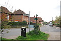
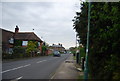
8
Great Chart Crossroads
Approaching "The Street" junction with Ninn Lane on the right at the Ashford end of the village. This road used to be the A28.
Cottage behind the chevron sign on the right is The Old Forge in Ninn Lane.
Image: © Dave Skinner
Taken: 14 Sep 2007
0.05 miles
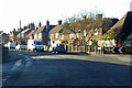
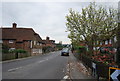
9
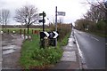
The long distance paths on Chart Road
Chart Road heads from Great Chart to the A28. The Greensand Way heads from Great Chart (behind the viewer) along Chart Avenue (on the left) towards the Godinton Estate. The Stour Valley Path also heads down Chart Avenue towards the estate, but it comes from central Ashford (on the right).
Image: © David Anstiss
Taken: 29 Nov 2009
0.06 miles
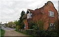
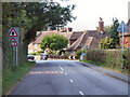
10
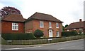
The Holders. The Street
Grade II listed. http://www.britishlistedbuildings.co.uk/en-180938-3-great-chart-with-singleton
Image: © N Chadwick
Taken: 15 Apr 2011
0.06 miles