IMAGES TAKEN NEAR TO
Myrtle Court, ASHFORD, TN23 3BJ
Introduction
This page details the photographs taken nearby to Myrtle Court, TN23 3BJ by members of the Geograph project.
The Geograph project started in 2005 with the aim of publishing, organising and preserving representative images for every square kilometre of Great Britain, Ireland and the Isle of Man.

There are currently over 7.5m images from over14,400 individuals and you can help contribute to the project by visiting https://www.geograph.org.uk
Image Map
Images are licensed for reuse under creativecommons.org/licenses/by-sa/2.0
Notes
- Clicking on the map will re-center to the selected point.
- The higher the marker number, the further away the image location is from the centre of the postcode.
Image Listing (42 Images Found)
Images are licensed for reuse under creativecommons.org/licenses/by-sa/2.0
Image
Details
Distance
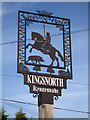
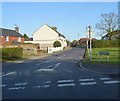
1
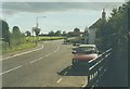
The crossroads at Kingsnorth, 1997
The main road is Ashford Road, while that to the left is Church Hill and to the right Pound Lane. The field beyond Church Hill is now the site of a development known as Myrtle Court. This was named after the late Myrtle Sankey. Her father moved to Pound Farm in 1920 and built a bungalow next door (in which she lived) which he called Rosyth in memory of a stallion he owned which won the Schweppes Gold Trophy in 1963 and 1964 and came second in 1965.
Image: © John Baker
Taken: 12 Oct 1997
0.01 miles
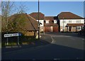
3
The crossroads at Kingsnorth
The main road is Ashford Road, while to the left - Church Hill and to the right - Pound Lane. Across Church Hill on the left of the main road is the development of Myrtle Court while on the right hand side of the main road is the Queens Head public house and across Pound Lane - Laguna Motorcycles Ltd.
Image: © John Baker
Taken: 31 Jan 2010
0.03 miles
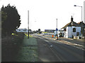
6
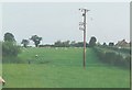
Mill Hill, Ashford Road, Kingsnorth in 1993
The meadow beyond the electricity pole is now the site of Myrtle Court see http://www.geograph.org.uk/photo/1691576
Image: © John Baker
Taken: Unknown
0.04 miles
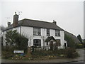
7
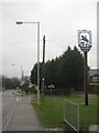
Kingsnorth Village Sign and Greensand Way
The long distance path crosses Ashford Road leading right along Church Hill, or left along Pound Lane. The sign has a metal information panel near a bench looking at the sign. Which reads 'This sign was designed and commissioned by Kingsnorth Parish Council in 2007 and was dedicated by the Revd. Canon Shelia McLachlan'.
Image: © David Anstiss
Taken: 21 Feb 2010
0.04 miles
10
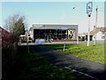
Laguna Ashford Triumph, Ashford Road
Official [motorcycle] dealers for Triumph, Yamaha, Suzuki, Kawasaki, KTM, Ducati, Honda and Harley-Davidson, with 5 stores in Maidstone and Ashford in Kent http://www.laguna.co.uk/ http://www.laguna.co.uk/
This is Image during its reconstruction.
Image: © John Baker
Taken: 17 Jan 2018
0.06 miles