IMAGES TAKEN NEAR TO
Bean Close, ASHFORD, TN23 3BG
Introduction
This page details the photographs taken nearby to Bean Close, TN23 3BG by members of the Geograph project.
The Geograph project started in 2005 with the aim of publishing, organising and preserving representative images for every square kilometre of Great Britain, Ireland and the Isle of Man.

There are currently over 7.5m images from over14,400 individuals and you can help contribute to the project by visiting https://www.geograph.org.uk
Image Map
Images are licensed for reuse under creativecommons.org/licenses/by-sa/2.0
Notes
- Clicking on the map will re-center to the selected point.
- The higher the marker number, the further away the image location is from the centre of the postcode.
Image Listing (76 Images Found)
Images are licensed for reuse under creativecommons.org/licenses/by-sa/2.0
Image
Details
Distance
2
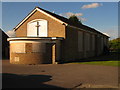
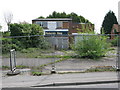
Abandoned Methodist Church
On Singleton Road, Great Chart. Has foundation stone near front which reads 'To the Glory of God. This stone was laid on 28th June 1962 by E.H. Richards Esq. J.P.'
Image: © David Anstiss
Taken: 28 Apr 2009
0.08 miles
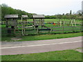
3
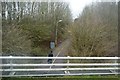
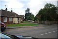
Turning circle at the end of Singleton Road
Image: © Nick Smith
Taken: 23 Apr 2009
0.09 miles
4
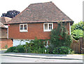
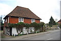
The Granary, Great Chart
Lovely old building next to the Bakehouse in Great Chart. Classic construction with tiles, common in many Kent villages.
Image: © Dave Skinner
Taken: 30 May 2003
0.10 miles
8
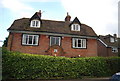
The Cottage, The Street, Great Chart
Grade II listed. http://www.britishlistedbuildings.co.uk/en-180940-the-cottage-great-chart-with-singleton
Image: © N Chadwick
Taken: 15 Apr 2011
0.12 miles
10
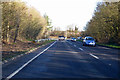
A28 towards Canterbury
Bypassing Great Chart to the left and most of Ashford to the right.
Image: © Robin Webster
Taken: 17 Jan 2019
0.12 miles