IMAGES TAKEN NEAR TO
Station Road, ASHFORD, TN23 1PH
Introduction
This page details the photographs taken nearby to Station Road, TN23 1PH by members of the Geograph project.
The Geograph project started in 2005 with the aim of publishing, organising and preserving representative images for every square kilometre of Great Britain, Ireland and the Isle of Man.

There are currently over 7.5m images from over14,400 individuals and you can help contribute to the project by visiting https://www.geograph.org.uk
Image Map
Images are licensed for reuse under creativecommons.org/licenses/by-sa/2.0
Notes
- Clicking on the map will re-center to the selected point.
- The higher the marker number, the further away the image location is from the centre of the postcode.
Image Listing (429 Images Found)
Images are licensed for reuse under creativecommons.org/licenses/by-sa/2.0
Image
Details
Distance
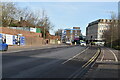
1
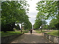
The Memorial Gardens, Ashford
Looking towards the town centre.
Image: © Jonathan Thacker
Taken: 5 Jul 2013
0.02 miles
2

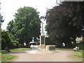
Memorial Gardens, Ashford
The Memorial Gardens were laid out in the 1920s on land donated to the town. The tower of St Mary's Church can be seen in the background.
Image: © Stephen McKay
Taken: 18 Mar 2010
0.03 miles


6
War Memorial, Memorial Gardens, Ashford
Image: © Jonathan Thacker
Taken: 5 Jul 2013
0.05 miles

10

Memorial Gardens, Ashford
This year's summer bedding.
Image: © John Baker
Taken: 2 Aug 2011
0.06 miles