IMAGES TAKEN NEAR TO
Regents Place, ASHFORD, TN23 1JX
Introduction
This page details the photographs taken nearby to Regents Place, TN23 1JX by members of the Geograph project.
The Geograph project started in 2005 with the aim of publishing, organising and preserving representative images for every square kilometre of Great Britain, Ireland and the Isle of Man.

There are currently over 7.5m images from over14,400 individuals and you can help contribute to the project by visiting https://www.geograph.org.uk
Image Map
Images are licensed for reuse under creativecommons.org/licenses/by-sa/2.0
Notes
- Clicking on the map will re-center to the selected point.
- The higher the marker number, the further away the image location is from the centre of the postcode.
Image Listing (346 Images Found)
Images are licensed for reuse under creativecommons.org/licenses/by-sa/2.0
Image
Details
Distance
1
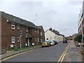
Forge Lane, Ashford
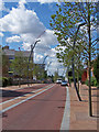
The Ashford ring road has changed dramatically in the last two years.
This part has been narrowed, is now bordered with trees, converted to two-way traffic, and has had some unusual bendy street lights installed.
Image: © Richard Dorrell
Taken: 30 Jul 2009
0.01 miles
2
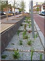
Street furniture in West Forge Lane
These stone gabions (rocks in cages), plants in gravel, expensive street lighting (£75,000 alone) trees in row and bench seating areas, are part of the new two-way road system around Ashford town centre. There was a clockwise one-way system. But when County Square shopping centre was being refurbished the council also decided to change the roads as well. ? Has it worked ?
Image: © David Anstiss
Taken: 28 Apr 2009
0.02 miles
3
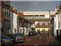
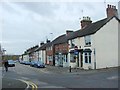
East Street
One way residential road between West Street and Regents Place.
Image: © Oast House Archive
Taken: 24 Nov 2010
0.02 miles
6
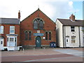
7th Ashford District Scout Headquarters
In converted Mission Church. Built in 1881. On West Forge Lane.
Image: © David Anstiss
Taken: 28 Apr 2009
0.03 miles
8
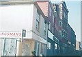
New Rents, Ashford in 1975
Taken on the corner of Apsley Street showing Kingsmans bakery closed and awaiting demolition along with the Lewis and Hyland building further along New Rents.
Image: © John Baker
Taken: Unknown
0.05 miles
9
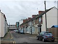
Junction of Godinton Road and West St from the West
Image: © Robert Eva
Taken: 30 Nov 2018
0.06 miles
10
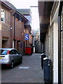
Ashford, Kent
'Geerings Passage' actually has no known name but was the passage from Park Street through to the High Street, beside Geerings stationery emporium... on the right, which has now become something else. The Geerings family ran the Kent Messenger newspaper among other things.
Image: © Iain Crump
Taken: 27 Aug 2007
0.06 miles