IMAGES TAKEN NEAR TO
Teal Lane, TN22 5LQ
Introduction
This page details the photographs taken nearby to Teal Lane, TN22 5LQ by members of the Geograph project.
The Geograph project started in 2005 with the aim of publishing, organising and preserving representative images for every square kilometre of Great Britain, Ireland and the Isle of Man.

There are currently over 7.5m images from over14,400 individuals and you can help contribute to the project by visiting https://www.geograph.org.uk
Image Map (Loading...)


Getting Data...Please wait
Leaflet Map data © OpenStreetMap
Images are licensed for reuse under creativecommons.org/licenses/by-sa/2.0
Notes
- Clicking on the map will re-center to the selected point.
- The higher the marker number, the further away the image location is from the centre of the postcode.
Image Listing (5 Images Found)
Images are licensed for reuse under creativecommons.org/licenses/by-sa/2.0
Image
Details
Distance
3
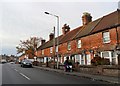
Bottom of Bird-in-Eye Hill (B2012), Framfield Road, Uckfield
The start of the ascent heading eastwards towards Framfield. On the outskirts of New Town, a suburb of Uckfield.
Image: © Patrick Roper
Taken: 24 Sep 2007
0.23 miles
4
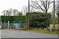
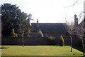
Water company compound, Uckfield
Just sneaking into this grid square at the foot of Bird-in-Eye Hill is this small installation where the B2102 crosses the Framfield Stream.
Image: © Robin Webster
Taken: 13 Mar 2010
0.23 miles