IMAGES TAKEN NEAR TO
Lyewood Way, UCKFIELD, TN22 5GL
Introduction
This page details the photographs taken nearby to Lyewood Way, TN22 5GL by members of the Geograph project.
The Geograph project started in 2005 with the aim of publishing, organising and preserving representative images for every square kilometre of Great Britain, Ireland and the Isle of Man.

There are currently over 7.5m images from over14,400 individuals and you can help contribute to the project by visiting https://www.geograph.org.uk
Image Map (Loading...)


Getting Data...Please wait
Leaflet Map data © OpenStreetMap
Images are licensed for reuse under creativecommons.org/licenses/by-sa/2.0
Notes
- Clicking on the map will re-center to the selected point.
- The higher the marker number, the further away the image location is from the centre of the postcode.
Image Listing (10 Images Found)
Images are licensed for reuse under creativecommons.org/licenses/by-sa/2.0
Image
Details
Distance
1
Safety fencing for building site near Uckfield
Image: © Dave Spicer
Taken: 16 Jul 2010
0.05 miles
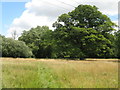
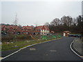
2
Road and footpath to Larch Spinney and The Old Laundry
Image: © Dave Spicer
Taken: 16 Jul 2010
0.06 miles
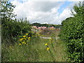
4
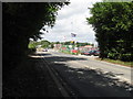
Eastbourne Road approaching site office of new house build
Image: © Dave Spicer
Taken: 16 Jul 2010
0.12 miles
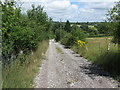
5
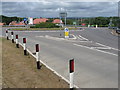
New roundabout for new housing estate on the outskirts of Uckfield
Image: © Dave Spicer
Taken: 16 Jul 2010
0.13 miles
6
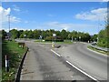
Eastbourne Road, near Uckfield
Eastbourne Road, on the outskirts of Uckfield in East Sussex.
The road name indicates that it was once a main road to Eastbourne on the Sussex coast. It formed part of the route of the A22, until Uckfield by-Pass was built. The A22 now follows the by-pass, and Eastbourne Road has been de-classified.
Image: © Malc McDonald
Taken: 29 Aug 2022
0.13 miles
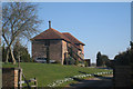
7
Meadow Views, Uckfield
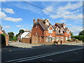
Meadow Views is a small development of houses on the outskirts of Uckfield in East Sussex.
Image: © Malc McDonald
Taken: 29 Aug 2022
0.19 miles
8
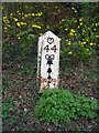
Old Milepost by the B2026, Eastbourne Road, Uckfield
Metal plate attached to wooden post by the B2026 (was A22), in parish of Uckfield (Wealden District), Eastbourne Road, between Timberley Gardens and Meadow View, in hedge between '40' sign and bus shelter, on West side of road. Bow Bells and Buckle iron plate, erected by the Horsebridge & Horeham turnpike trust in the 19th century.
Inscription reads:-
{Pelham Buckle}
44
{Bow & 4 Bells}
East Sussex HER.
HER Ref: MES21806 https://www.heritagegateway.org.uk/Gateway/Results_Single.aspx?uid=MES21806&resourceID=1026
Milestone Society National ID: SX_LLE44
Image: © Keith Sharp
Taken: 13 Apr 2008
0.20 miles