IMAGES TAKEN NEAR TO
New Town, UCKFIELD, TN22 5FY
Introduction
This page details the photographs taken nearby to New Town, TN22 5FY by members of the Geograph project.
The Geograph project started in 2005 with the aim of publishing, organising and preserving representative images for every square kilometre of Great Britain, Ireland and the Isle of Man.

There are currently over 7.5m images from over14,400 individuals and you can help contribute to the project by visiting https://www.geograph.org.uk
Image Map (Loading...)


Getting Data...Please wait
Leaflet Map data © OpenStreetMap
Images are licensed for reuse under creativecommons.org/licenses/by-sa/2.0
Notes
- Clicking on the map will re-center to the selected point.
- The higher the marker number, the further away the image location is from the centre of the postcode.
Image Listing (161 Images Found)
Images are licensed for reuse under creativecommons.org/licenses/by-sa/2.0
Image
Details
Distance

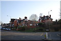
6
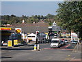
High Street
At Framfield Road junction.
Image: © Oast House Archive
Taken: 1 Oct 2011
0.05 miles


10
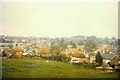
View of Uckfield in 1967
As seen from Victoria Pleasure Ground. A similar view can be found in the Francis Frith collection http://www.francisfrith.com/uckfield/photos/view-from-victoria-pleasure-ground-c1950_u1004/ but the modern day view has been obscured by a housing estate, with some houses being built along the northern boundary of the ground. On the left of the frame, the steeple of Holy Cross church, in Church Street, can be seen.
Image: © John Baker
Taken: 30 Apr 1967
0.05 miles