IMAGES TAKEN NEAR TO
Riverside, UCKFIELD, TN22 4EY
Introduction
This page details the photographs taken nearby to Riverside, TN22 4EY by members of the Geograph project.
The Geograph project started in 2005 with the aim of publishing, organising and preserving representative images for every square kilometre of Great Britain, Ireland and the Isle of Man.

There are currently over 7.5m images from over14,400 individuals and you can help contribute to the project by visiting https://www.geograph.org.uk
Image Map
Images are licensed for reuse under creativecommons.org/licenses/by-sa/2.0
Notes
- Clicking on the map will re-center to the selected point.
- The higher the marker number, the further away the image location is from the centre of the postcode.
Image Listing (17 Images Found)
Images are licensed for reuse under creativecommons.org/licenses/by-sa/2.0
Image
Details
Distance
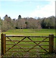
1
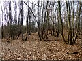
Gunbank Plantation
Bounded to the north and east by Riverside.
Image: © Simon Carey
Taken: 5 Feb 2023
0.07 miles
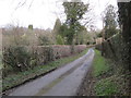
2
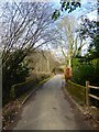
Riverside
The lane links Wilderness Lane to Nursery Lane following Tickerage Stream which it crosses at this point.
Image: © Simon Carey
Taken: 5 Feb 2023
0.07 miles
3
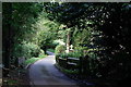
Riverside
An odd choice of road name, but a small stream does flow under the road at this location.
Image: © Peter Trimming
Taken: 18 Sep 2017
0.08 miles
4
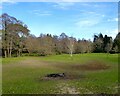
The Brook
The name of the field according to Framfield's 1840 tithe map that is bounded by Tickerage Stream to the north and Riverside to the west and south.
Image: © Simon Carey
Taken: 5 Feb 2023
0.10 miles
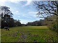
5
Brook Field
The name of the field according to Framfield's 1840 tithe map that is bounded by Riverside to the east, Gunbanks Farm to the west, Gunbank Plantation to the north and Tickerage Stream to the south. Beyond the latter is Image and along with a pond bay at the western end of the field next to the farm suggests this large field was once the hammer pond for Pounsley Furnace that operated between 1548 and 1733.
Image: © Simon Carey
Taken: 5 Feb 2023
0.11 miles
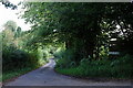
6
Riverside
This meandering road seems to take its name from the small stream, which is just out of picture, to the left.
Image: © Peter Trimming
Taken: 18 Sep 2017
0.12 miles
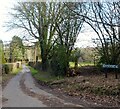
7
Riverside
The lane links Wilderness Lane to Nursery Lane following Tickerage Stream throughout its length. Her, having crossed the stream, it turns east at the junction with Sheepwash Lane.
Image: © Simon Carey
Taken: 5 Feb 2023
0.14 miles
9
House Field
The name of the field according to Framfield's 1840 tithe map located to the south of Riverside and east of Sheepwash Lane. The titular house is Image
Image: © Simon Carey
Taken: 5 Feb 2023
0.15 miles
10
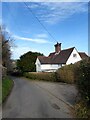
Newlands, Sheepwash Lane
Former farmhouse that looks like some parts date back to at least the 18th century.
Image: © Simon Carey
Taken: 5 Feb 2023
0.17 miles