IMAGES TAKEN NEAR TO
Mill Hill, UCKFIELD, TN22 3YH
Introduction
This page details the photographs taken nearby to Mill Hill, TN22 3YH by members of the Geograph project.
The Geograph project started in 2005 with the aim of publishing, organising and preserving representative images for every square kilometre of Great Britain, Ireland and the Isle of Man.

There are currently over 7.5m images from over14,400 individuals and you can help contribute to the project by visiting https://www.geograph.org.uk
Image Map (Loading...)


Getting Data...Please wait
Leaflet Map data © OpenStreetMap
Images are licensed for reuse under creativecommons.org/licenses/by-sa/2.0
Notes
- Clicking on the map will re-center to the selected point.
- The higher the marker number, the further away the image location is from the centre of the postcode.
Image Listing (24 Images Found)
Images are licensed for reuse under creativecommons.org/licenses/by-sa/2.0
Image
Details
Distance
1
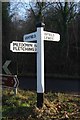
Old Direction Sign - Signpost near Shortbridge Mill, Fletching parish
Black iron cap finial - 3 arms; East Sussex wood by Shortbridge Road, in parish of Fletching (Wealden District), Shortbridge Road junction with Rocks Road (Piltdown to Uckfield), and Buckham Hill, South of Shortbridge, on grass triangle at junction.
Surveyed
Milestone Society National ID: SX_TQ4521B
Image: © Milestone Society
Taken: Unknown
0.07 miles
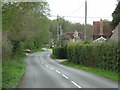
2
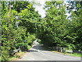
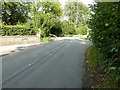
Shortbridge Road, near Uckfield
Shortbridge Road is a minor road passing through East Sussex countryside near the town of Uckfield.
Image: © Malc McDonald
Taken: 29 Aug 2022
0.07 miles
4
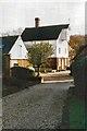
Shortbridge Mill Shortbridge
Formerly a water driven mill but later steam driven as the tall chimney indicates.
Image: © Dave Spicer
Taken: 10 Oct 2010
0.08 miles
5
Course of an old Roman Road at Shortbridge
The road intersected the junction and carried on to Ashdown Forest. The skid marks were not from a chariot.
Image: © Dave Spicer
Taken: 18 Sep 2011
0.08 miles
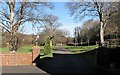
6
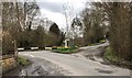
Road Junction at Shortbridge
Approaching a road junction with an adjacent footpath on the left.
Image: © Chris Thomas-Atkin
Taken: 1 Apr 2018
0.08 miles
7
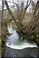
Stream at Shortbridge
A water sampling point for the Environment Agency, who sampled just after this photograph by dangling a bottle from the bridge. The stream drains the Maresfield area into the River Ouse.
Image: © Robin Webster
Taken: 11 Mar 2010
0.09 miles
8
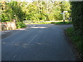
Road junction at Shortbridge
An old Roman Road intersects at this point.
Image: © Dave Spicer
Taken: 10 Oct 2010
0.09 miles
9
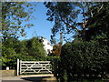
Entrance to Horse & Barge Farm, near Uckfield
Off Buckham Hill, Shortbridge.
Image: © Patrick Roper
Taken: 8 Feb 2008
0.10 miles
10
Shortbridge near Uckfield, East Sussex
Image: © nick macneill
Taken: 30 Apr 2010
0.12 miles