IMAGES TAKEN NEAR TO
Rushlake Green, HEATHFIELD, TN21 9PX
Introduction
This page details the photographs taken nearby to TN21 9PX by members of the Geograph project.
The Geograph project started in 2005 with the aim of publishing, organising and preserving representative images for every square kilometre of Great Britain, Ireland and the Isle of Man.

There are currently over 7.5m images from over14,400 individuals and you can help contribute to the project by visiting https://www.geograph.org.uk
Image Map
Images are licensed for reuse under creativecommons.org/licenses/by-sa/2.0
Notes
- Clicking on the map will re-center to the selected point.
- The higher the marker number, the further away the image location is from the centre of the postcode.
Image Listing (39 Images Found)
Images are licensed for reuse under creativecommons.org/licenses/by-sa/2.0
Image
Details
Distance
1
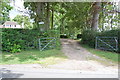
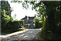
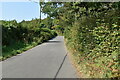
Entrance to Toll Lodge
A private residence.
Image: © Julian P Guffogg
Taken: 29 Jul 2012
0.03 miles
5
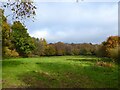
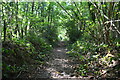
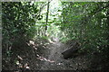
Toll Wood
On Warbleton's 1838 tithe map this current field was Toll Wood, the woodland that is marked on the modern map by that name was called Great Dean, Little Dean and Dean Toll. By the 1873 OS map this area had been grubbed and the name applied to the surrounding woods.
Image: © Simon Carey
Taken: 12 Nov 2022
0.05 miles