IMAGES TAKEN NEAR TO
Pennybridge Lane, MAYFIELD, TN20 6QB
Introduction
This page details the photographs taken nearby to Pennybridge Lane, TN20 6QB by members of the Geograph project.
The Geograph project started in 2005 with the aim of publishing, organising and preserving representative images for every square kilometre of Great Britain, Ireland and the Isle of Man.

There are currently over 7.5m images from over14,400 individuals and you can help contribute to the project by visiting https://www.geograph.org.uk
Image Map
Images are licensed for reuse under creativecommons.org/licenses/by-sa/2.0
Notes
- Clicking on the map will re-center to the selected point.
- The higher the marker number, the further away the image location is from the centre of the postcode.
Image Listing (15 Images Found)
Images are licensed for reuse under creativecommons.org/licenses/by-sa/2.0
Image
Details
Distance
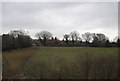
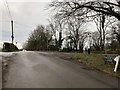
1
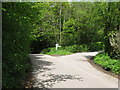
Pennybridge Lane meets Lake Street
Common Wood is on the left.
Image: © Dave Spicer
Taken: 25 May 2013
0.11 miles
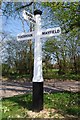
2
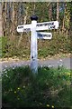
Old Direction Sign - Signpost by Lake Street, Mayfield parish
Black iron cap finial - 3 arms; East Sussex wood by the UC road, in parish of Mayfield (Wealden District), Lake Street, on grass island at junction of Pennybridge Lane with Lake Street.
Surveyed
Milestone Society National ID: SX_TQ6028A
Image: © Milestone Society
Taken: Unknown
0.11 miles

4
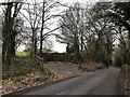
Entrance to Acorn Farm
Looking towards the farm from Coggins Mill Lane.
Image: © Chris Thomas-Atkin
Taken: 13 Jan 2019
0.13 miles
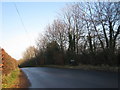
5
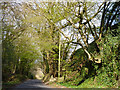
Tidebrook Road
Perched up in the tree on the right is a male Sparrowhawk, but you'll have to take my word for it!
Image: © Robin Webster
Taken: 6 Apr 2012
0.13 miles
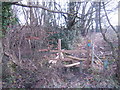
6
Old Direction Sign - Signpost by Tidebrook Road, Mayfield Parish
Black iron cap finial - 3 arms; East Sussex wood by the UC road, in parish of Mayfield (Wealden District), Tidebrook Road (Mayfield to Tidebrook), on verge, opposite junction of unnamed road with road from Mayfield to Tidebrook.
Surveyed
Milestone Society National ID: SX_TQ6028B.
Image: © Milestone Society
Taken: Unknown
0.13 miles
9
Footpath to Sharnden Old Manor Farm
Image: © Jonathan Billinger
Taken: 7 Feb 2007
0.15 miles
10
Junction on Coggins Mill Lane
A junction of lanes and tracks at a high point (131 metres) on Coggins Mill Lane.
Image: © Chris Thomas-Atkin
Taken: 13 Jan 2019
0.15 miles