IMAGES TAKEN NEAR TO
Five Ashes, MAYFIELD, TN20 6HJ
Introduction
This page details the photographs taken nearby to TN20 6HJ by members of the Geograph project.
The Geograph project started in 2005 with the aim of publishing, organising and preserving representative images for every square kilometre of Great Britain, Ireland and the Isle of Man.

There are currently over 7.5m images from over14,400 individuals and you can help contribute to the project by visiting https://www.geograph.org.uk
Image Map
Images are licensed for reuse under creativecommons.org/licenses/by-sa/2.0
Notes
- Clicking on the map will re-center to the selected point.
- The higher the marker number, the further away the image location is from the centre of the postcode.
Image Listing (17 Images Found)
Images are licensed for reuse under creativecommons.org/licenses/by-sa/2.0
Image
Details
Distance
2
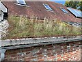
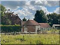
Green roof at Hospice in the Weald
Image: © Oast House Archive
Taken: 10 Aug 2021
0.07 miles
3
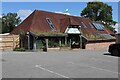
Hospice in the Weald, furniture shop
Image: © Oast House Archive
Taken: 10 Aug 2021
0.08 miles
5
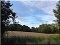
Six Acres
The name of the field according to Mayfield's 1844 tithe map located on the eastern side of Meres Lane.
Image: © Simon Carey
Taken: 21 Aug 2023
0.09 miles
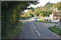
6
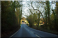
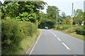
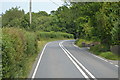
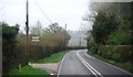
A straight on the A267
The A267 road from Eastbourne to Tunbridge Wells, although looking straight here, overall takes a rather indirect course through the High Weald. It is pieced together from segments of a network of lanes created by folk who had no interest in going from Eastbourne to Tunbridge Wells, or from Tunbridge Wells to Eastbourne.
Image: © Robin Webster
Taken: 3 Mar 2012
0.13 miles