IMAGES TAKEN NEAR TO
Station Approach, MAYFIELD, TN20 6HA
Introduction
This page details the photographs taken nearby to Station Approach, TN20 6HA by members of the Geograph project.
The Geograph project started in 2005 with the aim of publishing, organising and preserving representative images for every square kilometre of Great Britain, Ireland and the Isle of Man.

There are currently over 7.5m images from over14,400 individuals and you can help contribute to the project by visiting https://www.geograph.org.uk
Image Map (Loading...)


Getting Data...Please wait
Leaflet Map data © OpenStreetMap
Images are licensed for reuse under creativecommons.org/licenses/by-sa/2.0
Notes
- Clicking on the map will re-center to the selected point.
- The higher the marker number, the further away the image location is from the centre of the postcode.
Image Listing (37 Images Found)
Images are licensed for reuse under creativecommons.org/licenses/by-sa/2.0
Image
Details
Distance
1
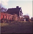
Mayfield Railway Station, East Sussex
The station was on the cuckoo line between Polegate and Tunbridge Wells. It is now a private residence. The platform signal box can be clearly seen still bearing its green and cream Southern Region colours.
Image: © nick macneill
Taken: 15 Nov 1985
0.00 miles
2
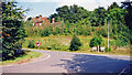
Mayfield: site of former station, 2000
View NE at junction of Fir Toll Road and A267 Mayfield by-pass, much of which was built on the formation of the railway: ex-LB%SCR (London) - Oxted - Eridge (to left) - (to right) Hailsham - Polegate - Eastbourne line. The station was closed 14/6/65 when the line was closed Eridge - Hailsham; Hailsham - Polegate was closed 9/9/68.
Image: © Ben Brooksbank
Taken: 3 Sep 2000
0.01 miles
3
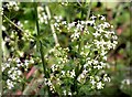
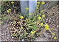
Hedge bedstraw by Love Lane in Mayfield
Hedge bedstraw or false baby's breath (Galium mollugo) is widespread in Britain on rough banks, hedges and waysides
Image: © Patrick Roper
Taken: 30 Jun 2005
0.03 miles
4

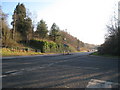
Fir Toll Road off the Mayfield bypass (A267)
Image: © N Chadwick
Taken: 31 Mar 2011
0.03 miles

6
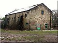
Old gas works building, Love Lane
The site, situated on the floor of an old quarry, is now being developed for housing. The sandstone may have been from the quarry. The old railway line passed nearby.
Image: © Patrick Roper
Taken: 25 Jan 2004
0.04 miles
7
Reflexed stonecrop at old gasworks site, Love Lane
Reflexed stonecrop (Sedum reflexum) is an introduced plant from Europe. It has been in cultivation since the 17th century and has escaped widely (as here). The leaves are edible and were formerly used in salads. Too many, however, are said to upset the stomach
Image: © Patrick Roper
Taken: 29 Jun 2005
0.04 miles
9
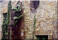
Ferns and ivy on wall
A wall of the old gas works in Love Lane
Image: © Patrick Roper
Taken: 30 May 2004
0.05 miles
10
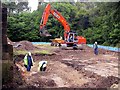
Groundworks in Love Lane
Site of the former gas works on the eastern side of Love Lane in a small disused quarry being prepared for housing development. The low blue fence around the level area is reptile exclusion fencing to stop slow-worms and other protected reptiles moving back into harm's way.
Image: © Patrick Roper
Taken: 6 Jun 2004
0.05 miles