IMAGES TAKEN NEAR TO
Witherenden Hill, ETCHINGHAM, TN19 7JW
Introduction
This page details the photographs taken nearby to Witherenden Hill, TN19 7JW by members of the Geograph project.
The Geograph project started in 2005 with the aim of publishing, organising and preserving representative images for every square kilometre of Great Britain, Ireland and the Isle of Man.

There are currently over 7.5m images from over14,400 individuals and you can help contribute to the project by visiting https://www.geograph.org.uk
Image Map
Images are licensed for reuse under creativecommons.org/licenses/by-sa/2.0
Notes
- Clicking on the map will re-center to the selected point.
- The higher the marker number, the further away the image location is from the centre of the postcode.
Image Listing (33 Images Found)
Images are licensed for reuse under creativecommons.org/licenses/by-sa/2.0
Image
Details
Distance
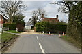
2
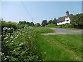
Roadside green at Holmshurst
This is near the junction of Spring Lane with the road through the hamlet of Holmshurst between Burwash Common and Stonegate. The roadside green runs along the east side of Holmshurst for quite some distance.
Image: © Marathon
Taken: 5 Jun 2016
0.01 miles
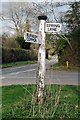
3
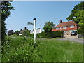
Signpost at Holmshurst
This is at the junction of Spring Lane with the road through the hamlet of Holmshurst between Burwash Common and Stonegate.
Image: © Marathon
Taken: 5 Jun 2016
0.02 miles
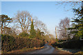
4
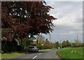
Minor road near Witherenden, East Sussex
Image: © nick macneill
Taken: 10 May 2013
0.02 miles
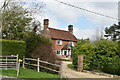
5
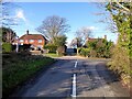
Ghyll Cottage, Swing Gate Hill
The house on the left was built after the Second World War. The roof of Peartree Cottage is visible on the right and is much older. Viewed from the junction with Spring Lane.
Image: © Simon Carey
Taken: 26 Dec 2022
0.02 miles
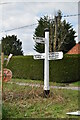
7
Direction Sign - Signpost near Witherenden Hill
Black iron cap finial - 2 arms; East Sussex wood by the UC road, in parish of Burwash (Rother District), unnamed road, on verge at junction of Spring Lane with unnamed road.
Surveyed
Milestone Society National ID: SX_TQ6425
Image: © Milestone Society
Taken: Unknown
0.03 miles