IMAGES TAKEN NEAR TO
Walkhurst Road, CRANBROOK, TN17 4DS
Introduction
This page details the photographs taken nearby to Walkhurst Road, TN17 4DS by members of the Geograph project.
The Geograph project started in 2005 with the aim of publishing, organising and preserving representative images for every square kilometre of Great Britain, Ireland and the Isle of Man.

There are currently over 7.5m images from over14,400 individuals and you can help contribute to the project by visiting https://www.geograph.org.uk
Image Map
Images are licensed for reuse under creativecommons.org/licenses/by-sa/2.0
Notes
- Clicking on the map will re-center to the selected point.
- The higher the marker number, the further away the image location is from the centre of the postcode.
Image Listing (20 Images Found)
Images are licensed for reuse under creativecommons.org/licenses/by-sa/2.0
Image
Details
Distance
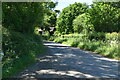
4
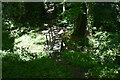
Footpath junction on Walkhurst Road
This stile is at the junction of a path No.WC350 leading left towards Nine Acre Wood and Mount le Hoe and path No.WC351 leading right towards the B2086 Benenden Road near Beacon Hill.
Image: © David Anstiss
Taken: 14 Jan 2010
0.09 miles