IMAGES TAKEN NEAR TO
Golford, CRANBROOK, TN17 3NX
Introduction
This page details the photographs taken nearby to TN17 3NX by members of the Geograph project.
The Geograph project started in 2005 with the aim of publishing, organising and preserving representative images for every square kilometre of Great Britain, Ireland and the Isle of Man.

There are currently over 7.5m images from over14,400 individuals and you can help contribute to the project by visiting https://www.geograph.org.uk
Image Map
Images are licensed for reuse under creativecommons.org/licenses/by-sa/2.0
Notes
- Clicking on the map will re-center to the selected point.
- The higher the marker number, the further away the image location is from the centre of the postcode.
Image Listing (36 Images Found)
Images are licensed for reuse under creativecommons.org/licenses/by-sa/2.0
Image
Details
Distance
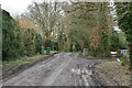
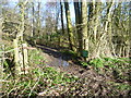
2
Path to Golford Road
This is actually a footpath, although after weeks of rain it resembled a stream more than a path. The path leads to Golford Road, and the course of a Roman road also lies just to the right and parallel to the path.
Image: © Marathon
Taken: 1 Feb 2014
0.03 miles
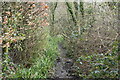
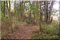
4
A meeting of footpaths
This is where a footpath from Coursehorne Farm meets a path which runs parallel to Golford Road. Whether turning left or right ahead the paths lead to Golford Road. The course of a Roman road also lies just ahead.
Image: © Marathon
Taken: 1 Feb 2014
0.07 miles
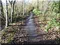
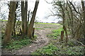
5
Footpath junction near Golford
A path from Golford Road leads straight on to Cherrybrook Farm on Chapel Lane. Another path leads right to Coursehorne Farm and Dulwich Prep. School.
Image: © David Anstiss
Taken: 20 Sep 2009
0.09 miles
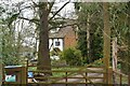
7
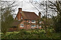
Whistler's
Grade II listed. https://historicengland.org.uk/listing/the-list/list-entry/1346272
Image: © N Chadwick
Taken: 18 Mar 2020
0.09 miles
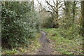
8
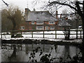
Whistlers, New Pond Road
On footpath to New Pond Road.
The Grade II listed http://list.english-heritage.org.uk/resultsingle.aspx?uid=1346272 timber framed hall house dates back to C15 and was once a public house.
Image: © Oast House Archive
Taken: 8 Feb 2010
0.10 miles
9
Starling's Cottage
Grade II listed. https://historicengland.org.uk/listing/the-list/list-entry/1347783
Image: © N Chadwick
Taken: 18 Mar 2020
0.10 miles