IMAGES TAKEN NEAR TO
Wheatfield Drive, CRANBROOK, TN17 3LU
Introduction
This page details the photographs taken nearby to Wheatfield Drive, TN17 3LU by members of the Geograph project.
The Geograph project started in 2005 with the aim of publishing, organising and preserving representative images for every square kilometre of Great Britain, Ireland and the Isle of Man.

There are currently over 7.5m images from over14,400 individuals and you can help contribute to the project by visiting https://www.geograph.org.uk
Image Map (Loading...)


Getting Data...Please wait
Leaflet Map data © OpenStreetMap
Images are licensed for reuse under creativecommons.org/licenses/by-sa/2.0
Notes
- Clicking on the map will re-center to the selected point.
- The higher the marker number, the further away the image location is from the centre of the postcode.
Image Listing (127 Images Found)
Images are licensed for reuse under creativecommons.org/licenses/by-sa/2.0
Image
Details
Distance


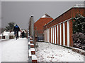
4
Deserted Council Offices, High St, Cranbrook
Image: © N Chadwick
Taken: 10 Apr 2010
0.07 miles
5
Former Council Offices
Wheatfield Drive is to the left. Public access was off High Street and staff access off Joyce Close.
Image: © Oast House Archive
Taken: 17 Dec 2010
0.07 miles
6
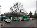
Retirement apartments under construction, High Street
Image: © Oast House Archive
Taken: 21 Feb 2015
0.07 miles
7
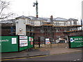
Retirement apartments under construction, High Street
Built on former police station site which was demolished in 2011.
Image: © Oast House Archive
Taken: 21 Feb 2015
0.07 miles
8
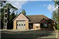
Cranbrook fire station
Cranbrook fire station, High Street, Cranbrook, Kent
Image: © Kevin Hale
Taken: 17 Oct 2007
0.08 miles