IMAGES TAKEN NEAR TO
Greenway, CRANBROOK, TN17 3LL
Introduction
This page details the photographs taken nearby to Greenway, TN17 3LL by members of the Geograph project.
The Geograph project started in 2005 with the aim of publishing, organising and preserving representative images for every square kilometre of Great Britain, Ireland and the Isle of Man.

There are currently over 7.5m images from over14,400 individuals and you can help contribute to the project by visiting https://www.geograph.org.uk
Image Map (Loading...)


Getting Data...Please wait
Leaflet Map data © OpenStreetMap
Images are licensed for reuse under creativecommons.org/licenses/by-sa/2.0
Notes
- Clicking on the map will re-center to the selected point.
- The higher the marker number, the further away the image location is from the centre of the postcode.
Image Listing (64 Images Found)
Images are licensed for reuse under creativecommons.org/licenses/by-sa/2.0
Image
Details
Distance
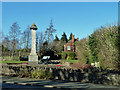
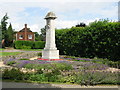
2
Gun by the Memorial
Cranbrook's war memorial by the way into town from the west.
Image: © Des Blenkinsopp
Taken: 5 Oct 2018
0.03 miles
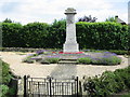
3
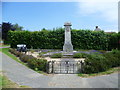
Cranbrook War Memorial
Cranbrook War Memorial is on a very prominent site as the village is approached from the south. It is on a triangle between Hartley Road (A229) which is to the left here and High Street which is to the right.
Image: © Marathon
Taken: 23 Jun 2014
0.03 miles
4
Cranbrook War Memorial
Cranbrook War Memorial is on a very prominent site as the village is approached from the south. It is on a triangle between Hartley Road (A229) which is to the left here and High Street.
Image: © Marathon
Taken: 23 Jun 2014
0.03 miles
5
Cranbrook war memorial
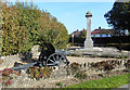
By it are a howitzer and a plough, presumably representing war and peace.
Image: © Robin Webster
Taken: 16 Feb 2014
0.03 miles
7
War memorial on the approach to Cranbrook
At the junction of The High Street and the A229 Angley Road
Image: © Nick Smith
Taken: 10 Jul 2008
0.04 miles
8
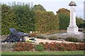
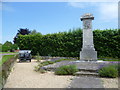
Cranbrook War Memorial, Howitzer and Plough
This war memorial is on the triangular green at the junction of the A229 Hartley Road and Cranbrook High Street (behind the Memorial). The cannon has a small plaque which reads '1917 German Howitzer Presented by War Trophies Commission to the Parish of Cranbrook in recognition of the contribution made by its residents during the 1914-18 War'. The plough also has a small plaque which reads 'This Ranscome plough was used in the local hop gardens during the 1914-18 War'.
Image: © David Anstiss
Taken: 20 Sep 2009
0.05 miles
10
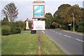
Cranbrook Town Sign
This sign is on a small triangular green at the junction of the A229 Hartley Road and Cranbrook High Street (on the right). The War Memorial is in the background.
Image: © David Anstiss
Taken: 20 Sep 2009
0.05 miles