IMAGES TAKEN NEAR TO
Carriers Road, CRANBROOK, TN17 3JT
Introduction
This page details the photographs taken nearby to Carriers Road, TN17 3JT by members of the Geograph project.
The Geograph project started in 2005 with the aim of publishing, organising and preserving representative images for every square kilometre of Great Britain, Ireland and the Isle of Man.

There are currently over 7.5m images from over14,400 individuals and you can help contribute to the project by visiting https://www.geograph.org.uk
Image Map (Loading...)


Getting Data...Please wait
Leaflet Map data © OpenStreetMap
Images are licensed for reuse under creativecommons.org/licenses/by-sa/2.0
Notes
- Clicking on the map will re-center to the selected point.
- The higher the marker number, the further away the image location is from the centre of the postcode.
Image Listing (317 Images Found)
Images are licensed for reuse under creativecommons.org/licenses/by-sa/2.0
Image
Details
Distance
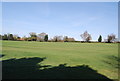
2
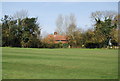
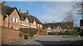
Cottage on the edge of the Recreation Ground, Cranbrook
Image: © N Chadwick
Taken: 10 Apr 2010
0.03 miles
3
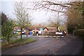
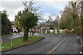
Cranbrook Church of England Primary School
At the end of Carriers Road.
Image: © David Anstiss
Taken: 22 Nov 2009
0.03 miles
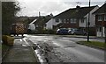
5

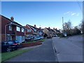
Carriers Road
Entrance to Cranbrook primary school to right.
Image: © Oast House Archive
Taken: 3 Mar 2011
0.06 miles
9
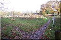
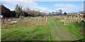
Footpath junction near Cranbrook Primary School
A path from Carriers Road leads straight on towards Quakers Lane. Another footpath heads left towards the A229 Angley Road.
Image: © David Anstiss
Taken: 22 Nov 2009
0.07 miles