IMAGES TAKEN NEAR TO
Hill Top, CRANBROOK, TN17 2NL
Introduction
This page details the photographs taken nearby to Hill Top, TN17 2NL by members of the Geograph project.
The Geograph project started in 2005 with the aim of publishing, organising and preserving representative images for every square kilometre of Great Britain, Ireland and the Isle of Man.

There are currently over 7.5m images from over14,400 individuals and you can help contribute to the project by visiting https://www.geograph.org.uk
Image Map
Images are licensed for reuse under creativecommons.org/licenses/by-sa/2.0
Notes
- Clicking on the map will re-center to the selected point.
- The higher the marker number, the further away the image location is from the centre of the postcode.
Image Listing (13 Images Found)
Images are licensed for reuse under creativecommons.org/licenses/by-sa/2.0
Image
Details
Distance
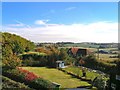
1
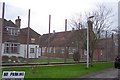
HMP Blantyre House
Blantyre House is an adult male category 'C/D' resettlement prison.
Image: © Jonathan Billinger
Taken: 13 Dec 2006
0.04 miles
3
Blantyre House Prison from Worms Hill Curtisden Green
Image: © Peter Skynner
Taken: 21 Oct 2003
0.06 miles
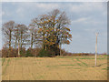
5
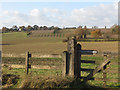
Fence and gate by Roundgreen Lane
A signature'd gate beside Roundgreen Lane, looking across fields and orchards towards Curtisden Green.
Image: © Oast House Archive
Taken: 7 Dec 2011
0.11 miles
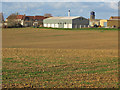
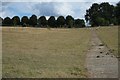
7
Great Horden Farm and Blantyre Prison
Image: © Peter Skynner
Taken: 24 Aug 2014
0.13 miles
8
Blantyre House (HM Prison)
As seen from Broadoak Wood (on left).
Image: © David Anstiss
Taken: 3 Jun 2009
0.14 miles
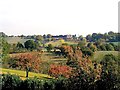
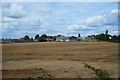
9
Broadoak Wood and Blantyre Prison from Worms Hill
Looking over Meadow View Cottages and Metlands towards the NE
Image: © Peter Skynner
Taken: 21 Oct 2003
0.15 miles
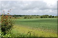
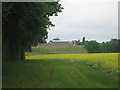
10
Fields near Great Hordon Farm
Looking from Roundgreen Lane.
Image: © Oast House Archive
Taken: 7 Dec 2011
0.17 miles