IMAGES TAKEN NEAR TO
WESTERHAM, TN16 9BE
Introduction
This page details the photographs taken nearby to TN16 9BE by members of the Geograph project.
The Geograph project started in 2005 with the aim of publishing, organising and preserving representative images for every square kilometre of Great Britain, Ireland and the Isle of Man.

There are currently over 7.5m images from over14,400 individuals and you can help contribute to the project by visiting https://www.geograph.org.uk
Image Map (Loading...)


Getting Data...Please wait
Leaflet Map data © OpenStreetMap
Images are licensed for reuse under creativecommons.org/licenses/by-sa/2.0
Notes
- Clicking on the map will re-center to the selected point.
- The higher the marker number, the further away the image location is from the centre of the postcode.
Image Listing (115 Images Found)
Images are licensed for reuse under creativecommons.org/licenses/by-sa/2.0
Image
Details
Distance


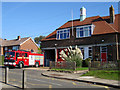
5
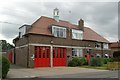
Biggin Hill fire station
Biggin Hill fire station, Kingsmead, Biggin Hill - part of the London Fire Brigade
Image: © Kevin Hale
Taken: 17 Jun 2007
0.05 miles
8
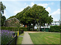
Northern gate, Biggin Hill recreation ground
This gives access along the grove of trees from Kingsmead, shared with the cemetery over the hedge to the right.
Image: © Robin Webster
Taken: 31 Jul 2011
0.07 miles
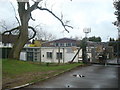
9

Way out of Biggin Hill Cemetery
Ahead is a recreation ground.
Image: © Robin Webster
Taken: 31 Jul 2011
0.07 miles
10
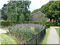
Flower bed, Biggin Hill recreation ground
There is a little bit of enclosed gardens in a corner.
Image: © Robin Webster
Taken: 31 Jul 2011
0.08 miles