IMAGES TAKEN NEAR TO
Kings Road, WESTERHAM, TN16 3XQ
Introduction
This page details the photographs taken nearby to Kings Road, TN16 3XQ by members of the Geograph project.
The Geograph project started in 2005 with the aim of publishing, organising and preserving representative images for every square kilometre of Great Britain, Ireland and the Isle of Man.

There are currently over 7.5m images from over14,400 individuals and you can help contribute to the project by visiting https://www.geograph.org.uk
Image Map (Loading...)


Getting Data...Please wait
Leaflet Map data © OpenStreetMap
Images are licensed for reuse under creativecommons.org/licenses/by-sa/2.0
Notes
- Clicking on the map will re-center to the selected point.
- The higher the marker number, the further away the image location is from the centre of the postcode.
Image Listing (21 Images Found)
Images are licensed for reuse under creativecommons.org/licenses/by-sa/2.0
Image
Details
Distance
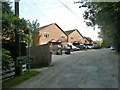
1
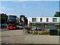
Bus route 320 at the terminus
Metrobus fleet number 976 marks time at George's Fitness Centre before setting off back to Catford.
Image: © Robin Webster
Taken: 31 Jul 2011
0.02 miles
2
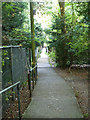
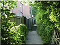
Footpath from Highfield Road to Kings Road, Biggin Hill
There is quite a height difference, involving frequent steps.
Image: © Robin Webster
Taken: 31 Jul 2011
0.03 miles
3
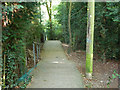
Footpath from Highfield Road to Kings Road, Biggin Hill
There is quite a height difference, involving frequent steps.
Image: © Robin Webster
Taken: 31 Jul 2011
0.05 miles
4
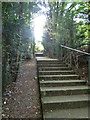
Footpath from Kings Road to Highfield Road, Biggin Hill
There is quite a height difference, involving frequent steps.
Image: © Robin Webster
Taken: 31 Jul 2011
0.07 miles
5
Footpath from Kings Road to Highfield Road, Biggin Hill
There is quite a height difference, involving frequent steps.
Image: © Robin Webster
Taken: 31 Jul 2011
0.09 miles
6
Highfield Road leading to Beech Road, Biggin Hill
One is just a prolongation of the other up to a dead-end.
Image: © Robin Webster
Taken: 31 Jul 2011
0.10 miles
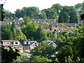
7
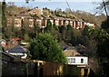
Housing at Biggin Hill
Taken from a footpath dropping down a valley side between Beech Road and Kings Road. The prominent row of houses on the far side is on Steeple Heights Drive.
Image: © Derek Harper
Taken: 9 Dec 2011
0.12 miles
8
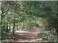
Woodland Path in Long Coppice
A path leads from Norheads Lane past a field, and then through this wood towards Beech Road.
Image: © David Anstiss
Taken: 9 Oct 2011
0.16 miles
9
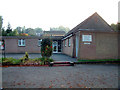
Valley Hall, Biggin Hill TN16
Valley Hall Community Centre and clinic, Sunningvale Avenue
Image: © Philip Talmage
Taken: 17 Oct 2005
0.17 miles
10
Housing, Biggin Hill
The terraces are on Timbertop Road, the chalets at a lower level on Melody Road.
Image: © Robin Webster
Taken: 31 Jul 2011
0.18 miles