IMAGES TAKEN NEAR TO
Hillcrest Road, WESTERHAM, TN16 3TY
Introduction
This page details the photographs taken nearby to Hillcrest Road, TN16 3TY by members of the Geograph project.
The Geograph project started in 2005 with the aim of publishing, organising and preserving representative images for every square kilometre of Great Britain, Ireland and the Isle of Man.

There are currently over 7.5m images from over14,400 individuals and you can help contribute to the project by visiting https://www.geograph.org.uk
Image Map
Images are licensed for reuse under creativecommons.org/licenses/by-sa/2.0
Notes
- Clicking on the map will re-center to the selected point.
- The higher the marker number, the further away the image location is from the centre of the postcode.
Image Listing (107 Images Found)
Images are licensed for reuse under creativecommons.org/licenses/by-sa/2.0
Image
Details
Distance

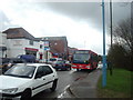
3
Stock Hill - Steep Hill 12%
Stock Hill, Biggin Hill. 12% steep hill up sign.
Image: © Adam Morse
Taken: 8 Jun 2009
0.08 miles
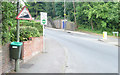
4

Sunningvale Avenue, Biggin Hill
On the right is the steep valley side below the plateau that carries the airfield.
Image: © Derek Harper
Taken: 9 Dec 2011
0.09 miles
10
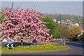
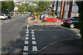
Sunningvale Avenue/Stock Hill/Norheads Lane Roundabout
A flowering cherry brightens up the roundabout where Sunningvale Avenue is crossed by Stock Hill and Norheads Lane in the lower part of Biggin Hill.
Image: © Ian Capper
Taken: 20 Apr 2011
0.10 miles