IMAGES TAKEN NEAR TO
Sunningvale Avenue, WESTERHAM, TN16 3TL
Introduction
This page details the photographs taken nearby to Sunningvale Avenue, TN16 3TL by members of the Geograph project.
The Geograph project started in 2005 with the aim of publishing, organising and preserving representative images for every square kilometre of Great Britain, Ireland and the Isle of Man.

There are currently over 7.5m images from over14,400 individuals and you can help contribute to the project by visiting https://www.geograph.org.uk
Image Map (Loading...)


Getting Data...Please wait
Leaflet Map data © OpenStreetMap
Images are licensed for reuse under creativecommons.org/licenses/by-sa/2.0
Notes
- Clicking on the map will re-center to the selected point.
- The higher the marker number, the further away the image location is from the centre of the postcode.
Image Listing (29 Images Found)
Images are licensed for reuse under creativecommons.org/licenses/by-sa/2.0
Image
Details
Distance
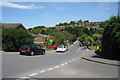
1
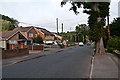
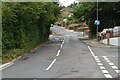
Sunningvale Avenue
Housing in the lower part of Biggin Hill.
Image: © Ian Capper
Taken: 22 Aug 2012
0.03 miles
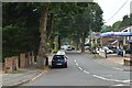
2
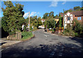
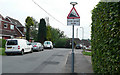
Polesteeple Hill, Biggin Hill, Kent TN16
Looking north from the end of Ricketts Hill Road.
Image: © Philip Talmage
Taken: 20 Oct 2005
0.06 miles
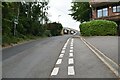
7
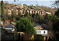
Housing at Biggin Hill
Taken from a footpath dropping down a valley side between Beech Road and Kings Road. The prominent row of houses on the far side is on Steeple Heights Drive.
Image: © Derek Harper
Taken: 9 Dec 2011
0.10 miles
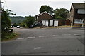
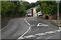
10
Polesteeple Hill - Steep Hill 20%
Polesteeple Hill, Biggin Hill. 20% steep hill down sign.
Image: © Adam Morse
Taken: 8 Jun 2009
0.13 miles