IMAGES TAKEN NEAR TO
Old Tye Avenue, WESTERHAM, TN16 3NA
Introduction
This page details the photographs taken nearby to Old Tye Avenue, TN16 3NA by members of the Geograph project.
The Geograph project started in 2005 with the aim of publishing, organising and preserving representative images for every square kilometre of Great Britain, Ireland and the Isle of Man.

There are currently over 7.5m images from over14,400 individuals and you can help contribute to the project by visiting https://www.geograph.org.uk
Image Map
Images are licensed for reuse under creativecommons.org/licenses/by-sa/2.0
Notes
- Clicking on the map will re-center to the selected point.
- The higher the marker number, the further away the image location is from the centre of the postcode.
Image Listing (85 Images Found)
Images are licensed for reuse under creativecommons.org/licenses/by-sa/2.0
Image
Details
Distance
9
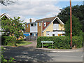
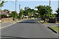
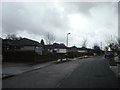
House on Aperfield Road
Fairly attractive yellow pitched roof house with hideous flat roof extension to the side with confusing a mix of brick uPVC weatherboarding and tile hanging. At junction with Village Green Avenue.
Image: © Oast House Archive
Taken: 28 Jul 2010
0.09 miles
10
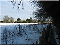
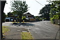
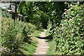
Footpath to Berry's Green
A path leads from Old Tye Avenue past Littlewood Farm towards Berry's Green Road.
Image: © David Anstiss
Taken: 9 Dec 2010
0.09 miles