IMAGES TAKEN NEAR TO
The Ridings, WESTERHAM, TN16 3LE
Introduction
This page details the photographs taken nearby to The Ridings, TN16 3LE by members of the Geograph project.
The Geograph project started in 2005 with the aim of publishing, organising and preserving representative images for every square kilometre of Great Britain, Ireland and the Isle of Man.

There are currently over 7.5m images from over14,400 individuals and you can help contribute to the project by visiting https://www.geograph.org.uk
Image Map (Loading...)


Getting Data...Please wait
Leaflet Map data © OpenStreetMap
Images are licensed for reuse under creativecommons.org/licenses/by-sa/2.0
Notes
- Clicking on the map will re-center to the selected point.
- The higher the marker number, the further away the image location is from the centre of the postcode.
Image Listing (114 Images Found)
Images are licensed for reuse under creativecommons.org/licenses/by-sa/2.0
Image
Details
Distance
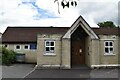
4

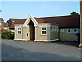
St. Mark's Parish Centre
Church Hall on Church Road, behind St. Mark's Parish Church.
Image: © David Anstiss
Taken: 9 Dec 2010
0.04 miles
8
St Mark's Centre, Biggin Hill
Biggin Hill Community Care Association operate here.
Image: © Robin Webster
Taken: 31 Jul 2011
0.05 miles