IMAGES TAKEN NEAR TO
Main Road, WESTERHAM, TN16 3JU
Introduction
This page details the photographs taken nearby to Main Road, TN16 3JU by members of the Geograph project.
The Geograph project started in 2005 with the aim of publishing, organising and preserving representative images for every square kilometre of Great Britain, Ireland and the Isle of Man.

There are currently over 7.5m images from over14,400 individuals and you can help contribute to the project by visiting https://www.geograph.org.uk
Image Map (Loading...)


Getting Data...Please wait
Leaflet Map data © OpenStreetMap
Images are licensed for reuse under creativecommons.org/licenses/by-sa/2.0
Notes
- Clicking on the map will re-center to the selected point.
- The higher the marker number, the further away the image location is from the centre of the postcode.
Image Listing (109 Images Found)
Images are licensed for reuse under creativecommons.org/licenses/by-sa/2.0
Image
Details
Distance
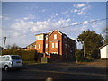
4
Biggin Hill Doctors' Surgery
Located at Stock Hill
Image: © Eric Lyus
Taken: 12 Oct 2008
0.04 miles
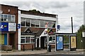
6
S&K Construction on Lebanon Gardens, Biggin Hill
This has been converted to a shop since 2014 and have constructed new windows and a fence when they arrived.
Image: © David Howard
Taken: 1 Jan 2017
0.04 miles
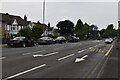
9
Stock Hill - Steep Hill 12%
Stock Hill, Biggin Hill. 12% steep hill down sign.
Image: © Adam Morse
Taken: 8 Jun 2009
0.06 miles