IMAGES TAKEN NEAR TO
Main Road, WESTERHAM, TN16 3JE
Introduction
This page details the photographs taken nearby to Main Road, TN16 3JE by members of the Geograph project.
The Geograph project started in 2005 with the aim of publishing, organising and preserving representative images for every square kilometre of Great Britain, Ireland and the Isle of Man.

There are currently over 7.5m images from over14,400 individuals and you can help contribute to the project by visiting https://www.geograph.org.uk
Image Map
Images are licensed for reuse under creativecommons.org/licenses/by-sa/2.0
Notes
- Clicking on the map will re-center to the selected point.
- The higher the marker number, the further away the image location is from the centre of the postcode.
Image Listing (40 Images Found)
Images are licensed for reuse under creativecommons.org/licenses/by-sa/2.0
Image
Details
Distance
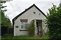
3
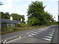
Main Road, Biggin Hill
This is at the southern edge of Biggin Hill where the countryside is reached to the south and to the east.
Image: © Marathon
Taken: 28 Aug 2017
0.02 miles
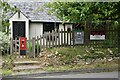
4
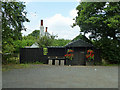
Summer plants & fresh eggs
A rather obscure pull-in off Main Road, the A233. It is more easily noticed from the bridleway which meets Main Road here.
Image: © Robin Webster
Taken: 31 Jul 2011
0.02 miles
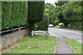
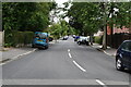
6
Bridleway towards Main Road, A233
It meets the road by Rose Cottage, ahead.
Image: © Robin Webster
Taken: 31 Jul 2011
0.03 miles

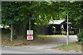
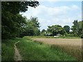
8

Wheat field east of Main Road, Biggin Hill
Image: © Robin Webster
Taken: 31 Jul 2011
0.04 miles