IMAGES TAKEN NEAR TO
Edward Road, WESTERHAM, TN16 3HL
Introduction
This page details the photographs taken nearby to Edward Road, TN16 3HL by members of the Geograph project.
The Geograph project started in 2005 with the aim of publishing, organising and preserving representative images for every square kilometre of Great Britain, Ireland and the Isle of Man.

There are currently over 7.5m images from over14,400 individuals and you can help contribute to the project by visiting https://www.geograph.org.uk
Image Map (Loading...)


Getting Data...Please wait
Leaflet Map data © OpenStreetMap
Images are licensed for reuse under creativecommons.org/licenses/by-sa/2.0
Notes
- Clicking on the map will re-center to the selected point.
- The higher the marker number, the further away the image location is from the centre of the postcode.
Image Listing (22 Images Found)
Images are licensed for reuse under creativecommons.org/licenses/by-sa/2.0
Image
Details
Distance
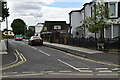
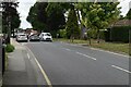
3
Aperfield Road at the junction of Main Road, Biggin Hill
Image: © David Howard
Taken: 20 Apr 2014
0.08 miles
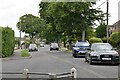
5
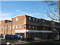
Biggin Hill Tesco Express
On the A233 Main Road. Very close to the large Waitrose Supermarket.
Image: © David Anstiss
Taken: 9 Dec 2010
0.10 miles
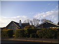

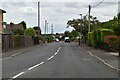
10
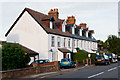
Coronation Terrace
A row of houses built in 1902, reputedly for railway workers for the aborted Orpington and Tatsfield Light Railway, whose Biggin Hill Station was to have been situated just beyond here. The name commemorates the coronation of Edward VII which took place that year.
Image: © Ian Capper
Taken: 17 Aug 2012
0.15 miles