IMAGES TAKEN NEAR TO
Hanbury Drive, WESTERHAM, TN16 3EN
Introduction
This page details the photographs taken nearby to Hanbury Drive, TN16 3EN by members of the Geograph project.
The Geograph project started in 2005 with the aim of publishing, organising and preserving representative images for every square kilometre of Great Britain, Ireland and the Isle of Man.

There are currently over 7.5m images from over14,400 individuals and you can help contribute to the project by visiting https://www.geograph.org.uk
Image Map
Images are licensed for reuse under creativecommons.org/licenses/by-sa/2.0
Notes
- Clicking on the map will re-center to the selected point.
- The higher the marker number, the further away the image location is from the centre of the postcode.
Image Listing (81 Images Found)
Images are licensed for reuse under creativecommons.org/licenses/by-sa/2.0
Image
Details
Distance
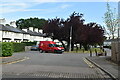
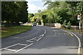
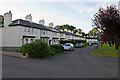
2
Hanbury Drive
Part of the former married quarters for RAF Biggin Hill, now a gated estate.
Image: © Ian Capper
Taken: 17 Aug 2012
0.06 miles
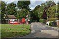
4
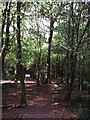
Footpath into Saltbox Hill
A footpath leads down from Grice Avenue in Biggin Hill through the SSSI woods towards Jewels Hill (road).
See http://en.wikipedia.org/wiki/Saltbox_Hill for more details about the woods.
Image: © David Anstiss
Taken: 9 Oct 2011
0.08 miles
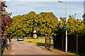
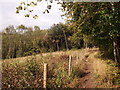
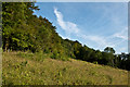
6
Saltbox Hill nature reserve
An area of downland on the left has been cleared of encroaching scrub and fenced, presumably to contain grazing animals, although none were seen in January.
Image: © Robin Webster
Taken: 22 Jan 2012
0.09 miles
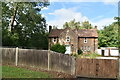
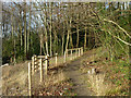
7
Footpath on Saltbox Hill
A path leads from Saltbox Hill (road) into the SSSI Wood (on the side of a valley) and onwards to Ashmore Farm.
Image: © David Anstiss
Taken: 9 Oct 2011
0.09 miles
8
Vincent Square
Former married quarters for personnel at RAF Biggin Hill, built in 1929. Some were damaged by bombing in World War II and demolished, although the gaps have recently been filled in a consistent style to the remaining houses, restoring the uniform appearance of the square (presumably as part of the adjacent Leavesden development in around 2007-8). The original buildings are all grade II listed: in this photo are nos 1-4 (the nearest block) - see www.historicengland.org.uk/listing/the-list/list-entry/1391590, nos 6-8 (the far three of the next block, no 5 being a replacement build) - see www.historicengland.org.uk/listing/the-list/list-entry/1391591 and nos 9-12 and 13-16 (the far two blocks) - see www.historicengland.org.uk/listing/the-list/list-entry/1391596 and www.historicengland.org.uk/listing/the-list/list-entry/1391637 respectively.
Image: © Ian Capper
Taken: 17 Aug 2012
0.10 miles
9
Saltbox Hill LNR
Chalk downland reserve owned by the London Wildlife Trust and recognised as one of the richest sites in Greater London. Charles Darwin, whose Down House was a mile or so distant (he didn't then have Biggin Hill Airfield to contend with!), frequented it.
Image: © Ian Capper
Taken: 17 Aug 2012
0.10 miles