IMAGES TAKEN NEAR TO
Westerham Road, WESTERHAM, TN16 2EX
Introduction
This page details the photographs taken nearby to Westerham Road, TN16 2EX by members of the Geograph project.
The Geograph project started in 2005 with the aim of publishing, organising and preserving representative images for every square kilometre of Great Britain, Ireland and the Isle of Man.

There are currently over 7.5m images from over14,400 individuals and you can help contribute to the project by visiting https://www.geograph.org.uk
Image Map
Images are licensed for reuse under creativecommons.org/licenses/by-sa/2.0
Notes
- Clicking on the map will re-center to the selected point.
- The higher the marker number, the further away the image location is from the centre of the postcode.
Image Listing (27 Images Found)
Images are licensed for reuse under creativecommons.org/licenses/by-sa/2.0
Image
Details
Distance
1
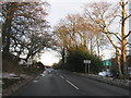
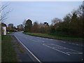
The A25 Westerham Road enters Kent
This road leads from Limpsfield (in Surrey) towards Westerham (in Kent).
On the right, a sign welcomes drivers to Surrey.
Image: © David Anstiss
Taken: 9 Dec 2010
0.04 miles
2
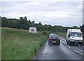
Sevenoaks District : Surrey Sign
The Surrey sign off of the A25 with the countryside behind it.
Image: © Lewis Clarke
Taken: 8 Aug 2015
0.06 miles
3
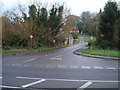
The most famous lane in the UK?
Clacket Lane itself is nothing much, being largely a single track country lane (see Image for junction with A25, including "single track road" sign). It would be virtually unknown if it were not for the fact that where it crosses the M25 north of here is the site for Clacket Lane services, one of the largest and busiest services on the UK motorway network. It also makes a virtually daily appearance on radio traffic bulletins, due to westbound traffic in the morning peak almost always jamming up in the stretch of the motorway from junction 5 near Sevenoaks to here.
Image: © Ian Capper
Taken: 26 Jun 2008
0.06 miles
6
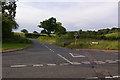
A25/Clacket Lane junction
See Image for background.
Image: © Ian Capper
Taken: 26 Jun 2008
0.07 miles
7
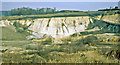
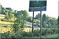
Moorhouse Sandpits, west of Westerham, 1970
View NE from A25 road.
Image: © Ben Brooksbank
Taken: 1 Mar 1970
0.08 miles
8
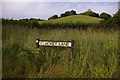
Tandridge : Moorhouse Road
Looking up Moorhouse Road from Westerham Road.
Image: © Lewis Clarke
Taken: 8 Aug 2015
0.13 miles
9
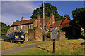
Moorhouse Cottages
Grade II listed 16th century cottages, one of a small group on Moorhouse Road near its junction with A25. The National Trust sign applies only to this small grass triangle, but it owns a number of other areas of land nearby.
Image: © Ian Capper
Taken: 2 Jul 2008
0.13 miles